File:Czechered landscape ESA359991.jpg

Original file (2,599 × 1,299 pixels, file size: 5.31 MB, MIME type: image/jpeg)
Captions
Captions
Summary edit
| Description |
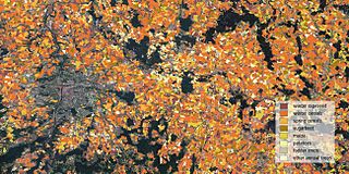
English: Different types of crops growing east of the Czech capital, Prague (left), are distinguished in this land cover classification image.
This crop map was created by combining over 1000 scenes from the Sentinel-1, Sentinel-2 and Landsat-8 satellites taken over the course of 2015. With its 13 spectral bands, the Sentinel-2 mission for Europe’s Copernicus programme is the first optical Earth observation mission of its kind to include three bands in the ‘red edge’, which provide key information on vegetation state. Sentinel-2 is designed to provide images that can be used to distinguish between different crop types as well as data on numerous plant indices, such as leaf area, leaf chlorophyll and leaf water – all essential to monitor plant growth accurately. This image was produced in collaboration with the European Commission (lead by the Joint Research Centre), the State Agricultural Intervention Fund of the Czech Republic and ESA. |
| Date | |
| Source | http://www.esa.int/spaceinimages/Images/2016/05/Czechered_landscape |
| Author | European Space Agency |
| Permission (Reusing this file) |
DUE Sentinel-2 for Agriculture project; contains modified Copernicus Sentinel data (2015),CC BY-SA 3.0 IGO |
| Title | Czechered landscape |
| Location | Czech Republic |
| Keywords | Agriculture; Crops |
| Set | Living Planet Symposium 2016 |
| Mission | Sentinel-1 |
| Activity | Observing the Earth |
Licensing edit
- You are free:
- to share – to copy, distribute and transmit the work
- to remix – to adapt the work
- Under the following conditions:
- attribution – You must give appropriate credit, provide a link to the license, and indicate if changes were made. You may do so in any reasonable manner, but not in any way that suggests the licensor endorses you or your use.
- share alike – If you remix, transform, or build upon the material, you must distribute your contributions under the same or compatible license as the original.
File history
Click on a date/time to view the file as it appeared at that time.
| Date/Time | Thumbnail | Dimensions | User | Comment | |
|---|---|---|---|---|---|
| current | 16:00, 6 May 2017 | | 2,599 × 1,299 (5.31 MB) | Fæ (talk | contribs) | == {{int:filedesc}} == {{information | description = {{en|1=Different types of crops growing east of the Czech capital, Prague (left), are distinguished in this land cover classification image. This crop map was created by combining over 1000 scenes fr... |
You cannot overwrite this file.
File usage on Commons
The following 2 pages use this file:
File usage on other wikis
The following other wikis use this file:
- Usage on cs.wikipedia.org