File:Czechoslovakia 1939 es.SVG

Size of this PNG preview of this SVG file: 800 × 326 pixels. Other resolutions: 320 × 130 pixels | 640 × 260 pixels | 1,024 × 417 pixels | 1,280 × 521 pixels | 2,560 × 1,042 pixels | 1,069 × 435 pixels.
Original file (SVG file, nominally 1,069 × 435 pixels, file size: 115 KB)
Captions
Captions
Add a one-line explanation of what this file represents
| Description |
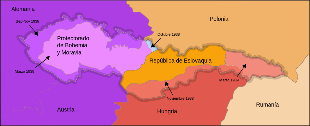
Français : Carte de la Tchécoslovaquie aprés 1939
English: Map of Czechoslovakia after 1939
Español: Mapa de Checoslovaquia tras 1939 |
| Date | (UTC) |
| Source | |
| Author |
16:36, 13 September 2007 (UTC)
|
| This is a retouched picture, which means that it has been digitally altered from its original version. Modifications: Spanish version, names in Spanish. The original can be viewed here: Czechoslovakia 1939.SVG:
|
I, the copyright holder of this work, hereby publish it under the following license:
This file is licensed under the Creative Commons Attribution-Share Alike 3.0 Unported license.
- You are free:
- to share – to copy, distribute and transmit the work
- to remix – to adapt the work
- Under the following conditions:
- attribution – You must give appropriate credit, provide a link to the license, and indicate if changes were made. You may do so in any reasonable manner, but not in any way that suggests the licensor endorses you or your use.
- share alike – If you remix, transform, or build upon the material, you must distribute your contributions under the same or compatible license as the original.
Original upload log edit
This image is a derivative work of the following images:
- File:Czechoslovakia_1939.SVG licensed with Cc-by-sa-3.0
- 2008-06-22T13:38:54Z Themightyquill 1069x435 (117229 Bytes)
- 2008-06-09T22:18:44Z Themightyquill 1069x435 (126028 Bytes)
- 2008-06-09T15:59:30Z Themightyquill 1069x435 (122677 Bytes) {{Information |Description={{fr|Carte de la Tchécoslovaquie aprés 1939}} {{en|Map of Czechoslovakia after 1939}} |Source=*[[:Image:First_Czechoslovak_Republic.SVG|]] *[[:Image:GDR.png|Image:GDR.png]] |Date=2008-06-09 15:56
Uploaded with derivativeFX
File history
Click on a date/time to view the file as it appeared at that time.
| Date/Time | Thumbnail | Dimensions | User | Comment | |
|---|---|---|---|---|---|
| current | 22:06, 10 January 2010 | 1,069 × 435 (115 KB) | Rowanwindwhistler (talk | contribs) | Wrong date of annexation of Rutenia to Hungary corrected | |
| 12:00, 1 January 2010 | 1,069 × 435 (115 KB) | Rowanwindwhistler (talk | contribs) | {{Information |Description={{fr|Carte de la Tchécoslovaquie aprés 1939}} {{en|Map of Czechoslovakia after 1939}} {{es|Mapa de Checoslovaquia tras 1939}} |Source=*File:Czechoslovakia_1939.SVG |Date=2010-01-01 11:58 (UTC) |Author=*[[:File:Czechoslo |
You cannot overwrite this file.
File usage on Commons
The following 16 pages use this file:
- File:Czechoslovakia 1939.SVG
- File:Czechoslovakia 1939 be-x-old.SVG
- File:Czechoslovakia 1939 br.SVG
- File:Czechoslovakia 1939 ca.SVG
- File:Czechoslovakia 1939 de.svg
- File:Czechoslovakia 1939 hu.svg
- File:Czechoslovakia 1939 ka.png
- File:Czechoslovakia 1939 lv.svg
- File:Czechoslovakia 1939 no.svg
- File:Czechoslovakia 1939 ru.SVG
- File:Czechoslovakia 1939 sv.svg
- File:Czechoslovakia 1939 zh.svg
- File:Tchécoslovaquie 1939.SVG
- File:Československa 1939 cs.SVG
- File:Československa 1939 sk.SVG
- Template:Other versions/Czechoslovakia 1939
File usage on other wikis
The following other wikis use this file:
- Usage on es.wikipedia.org