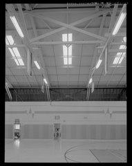
File:DETAIL ELEVATION SHOWING THE ROOF TRUSSES, PURLINS, AND SKYLIGHT. NOTE THE DOORS TO THE WEIGHTLIFTING ROOM. VIEW FACING SOUTHEAST - U.S. Naval Base, Pearl Harbor, Gymnasium HABS HI,2-PEHA,150-17.tif

Size of this JPG preview of this TIF file: 478 × 600 pixels. Other resolutions: 191 × 240 pixels | 382 × 480 pixels | 612 × 768 pixels | 816 × 1,024 pixels | 1,632 × 2,048 pixels | 3,987 × 5,004 pixels.
Original file (3,987 × 5,004 pixels, file size: 38.08 MB, MIME type: image/tiff)
Captions
Captions
Add a one-line explanation of what this file represents
Summary edit
| Photographer |
Franzen, David |
|||
| Title |
DETAIL ELEVATION SHOWING THE ROOF TRUSSES, PURLINS, AND SKYLIGHT. NOTE THE DOORS TO THE WEIGHTLIFTING ROOM. VIEW FACING SOUTHEAST - U.S. Naval Base, Pearl Harbor, Gymnasium Building, North Waterfront and Pierce Street near Berth S-13, Pearl City, Honolulu County, HI |
|||
| Depicted place | Hawaii; Honolulu County; Pearl City | |||
| Date | 2008 | |||
| Dimensions | 4 x 5 in. | |||
| Current location |
Library of Congress Prints and Photographs Division Washington, D.C. 20540 USA http://hdl.loc.gov/loc.pnp/pp.print |
|||
| Accession number |
HABS HI,2-PEHA,150-17 |
|||
| Credit line |
|
|||
| Notes |
|
|||
| References |
|
|||
| Source | https://www.loc.gov/pictures/item/hi0452.photos.576234p | |||
| Permission (Reusing this file) |
|

| Object location | | View this and other nearby images on: OpenStreetMap |
|---|
File history
Click on a date/time to view the file as it appeared at that time.
| Date/Time | Thumbnail | Dimensions | User | Comment | |
|---|---|---|---|---|---|
| current | 03:00, 12 July 2014 |  | 3,987 × 5,004 (38.08 MB) | Fæ (talk | contribs) | GWToolset: Creating mediafile for Fæ. HABS 11 July 2014 (1001:1200) |
You cannot overwrite this file.
File usage on Commons
The following page uses this file: