File:DETAIL OF BUILDER'S PLATE WHICH READS 'BUILT 1906 BY THE CHICAGO AND ALTON RY. CO.; G.H. KIMBALL CHIEF ENGINEER; W.M. HUGHES CONSULTING ENG'R; PAGE and SHNABLE PATENTEES' - HAER ILL, 16-CHIG, 114-4.tif
Size of this JPG preview of this TIF file: 476 × 599 pixels. Other resolutions: 191 × 240 pixels | 381 × 480 pixels | 610 × 768 pixels | 813 × 1,024 pixels | 1,626 × 2,048 pixels | 3,971 × 5,000 pixels.
Original file (3,971 × 5,000 pixels, file size: 18.94 MB, MIME type: image/tiff)
Captions
Captions
Add a one-line explanation of what this file represents
Summary edit
| Title |
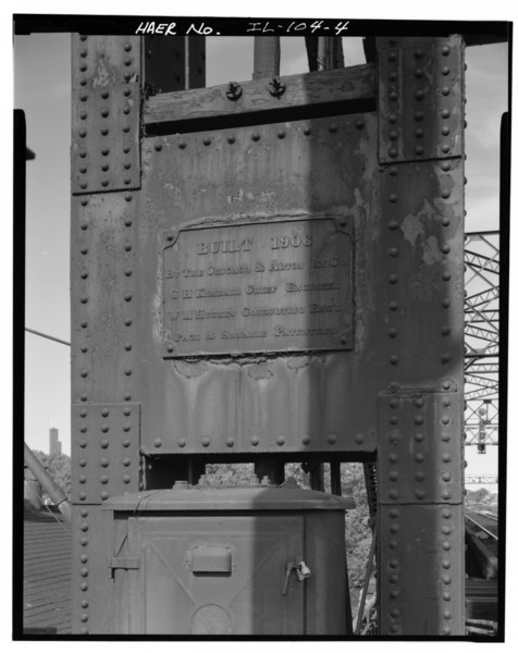
DETAIL OF BUILDER'S PLATE WHICH READS 'BUILT 1906 BY THE CHICAGO AND ALTON RY. CO.; G.H. KIMBALL CHIEF ENGINEER; W.M. HUGHES CONSULTING ENG'R; PAGE and SHNABLE PATENTEES' - Chicago and Alton Railroad Bridge, Spanning South Branch of Chicago River, Chicago, Cook County, IL |
|||
| Description |
Hughes, William M; Kelly and Atkinson Company; American Bridge Company; Page, John W |
|||
| Depicted place | Illinois; Cook County; Chicago | |||
| Date | Documentation compiled after 1968 | |||
| Dimensions | 4 x 5 in. | |||
| Current location |
Library of Congress Prints and Photographs Division Washington, D.C. 20540 USA http://hdl.loc.gov/loc.pnp/pp.print |
|||
| Accession number |
HAER ILL, 16-CHIG, 114-4 |
|||
| Credit line |
|
|||
| Notes |
|
|||
| Source | https://www.loc.gov/pictures/item/il0670.photos.037292p | |||
| Permission (Reusing this file) |
|

| Object location | | View this and other nearby images on: OpenStreetMap |
|---|
File history
Click on a date/time to view the file as it appeared at that time.
| Date/Time | Thumbnail | Dimensions | User | Comment | |
|---|---|---|---|---|---|
| current | 07:25, 17 July 2014 |  | 3,971 × 5,000 (18.94 MB) | Fæ (talk | contribs) | GWToolset: Creating mediafile for Fæ. HABS 16 July 2014 (1201:1400) |
You cannot overwrite this file.
File usage on Commons
The following page uses this file: