File:DETAIL OF COLUMN CAPITAL OF EAST ROTUNDA - Philadelphia Exchange Company, 143 South Third Street, Philadelphia, Philadelphia County, PA HABS PA,51-PHILA,137-10.jpg

Size of this preview: 432 × 600 pixels. Other resolutions: 173 × 240 pixels | 346 × 480 pixels | 553 × 768 pixels | 738 × 1,024 pixels | 1,475 × 2,048 pixels | 3,602 × 5,000 pixels.
Original file (3,602 × 5,000 pixels, file size: 2.45 MB, MIME type: image/jpeg)
Captions
Captions
Add a one-line explanation of what this file represents
Summary edit
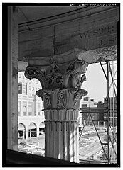
| DETAIL OF COLUMN CAPITAL OF EAST ROTUNDA - Philadelphia Exchange Company, 143 South Third Street, Philadelphia, Philadelphia County, PA
( |
||||||||||||||||||||||||||
|---|---|---|---|---|---|---|---|---|---|---|---|---|---|---|---|---|---|---|---|---|---|---|---|---|---|---|
| Photographer |
Related names:
|
|||||||||||||||||||||||||
| Title |
DETAIL OF COLUMN CAPITAL OF EAST ROTUNDA - Philadelphia Exchange Company, 143 South Third Street, Philadelphia, Philadelphia County, PA |
|||||||||||||||||||||||||
| Depicted place | Pennsylvania; Philadelphia County; Philadelphia | |||||||||||||||||||||||||
| Date | 1964 or 1965 | |||||||||||||||||||||||||
| Dimensions | 5 x 7 in. | |||||||||||||||||||||||||
| Current location |
Library of Congress Prints and Photographs Division Washington, D.C. 20540 USA http://hdl.loc.gov/loc.pnp/pp.print |
|||||||||||||||||||||||||
| Accession number |
HABS PA,51-PHILA,137-10 |
|||||||||||||||||||||||||
| Credit line |
|
|||||||||||||||||||||||||
| Notes |
|
|||||||||||||||||||||||||
| References |
|
|||||||||||||||||||||||||
| Source | https://www.loc.gov/pictures/item/pa1045.photos.137116p | |||||||||||||||||||||||||
| Permission (Reusing this file) |
|
|||||||||||||||||||||||||

| Object location | | View this and other nearby images on: OpenStreetMap |
|---|
File history
Click on a date/time to view the file as it appeared at that time.
| Date/Time | Thumbnail | Dimensions | User | Comment | |
|---|---|---|---|---|---|
| current | 16:07, 2 September 2023 | | 3,602 × 5,000 (2.45 MB) | Althair (talk | contribs) | Uploaded own work with UploadWizard |
You cannot overwrite this file.
File usage on Commons
The following page uses this file:
File usage on other wikis
The following other wikis use this file:
- Usage on es.wikipedia.org