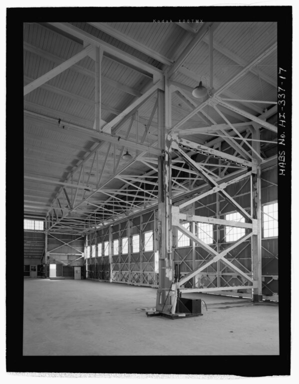
File:DETAIL VIEW OF THE BRACED I-BEAM COLUMNS AT THE END OF THE CENTER FLAT TRUSS OF THE ROOF. NOTE THE ORIGINAL LIGHT FIXTURE WITH BENT CONDUIT TUBING. VIEW FACING SOUTHEAST. - U.S. HABS HI,2-PEHA,171-17.tif

Size of this JPG preview of this TIF file: 467 × 599 pixels. Other resolutions: 187 × 240 pixels | 374 × 480 pixels | 598 × 768 pixels | 798 × 1,024 pixels | 1,595 × 2,048 pixels | 4,379 × 5,621 pixels.
Original file (4,379 × 5,621 pixels, file size: 23.48 MB, MIME type: image/tiff)
Captions
Captions
Add a one-line explanation of what this file represents
Summary edit
| Photographer |
Franzen, David Related names:
|
|||
| Title |
DETAIL VIEW OF THE BRACED I-BEAM COLUMNS AT THE END OF THE CENTER FLAT TRUSS OF THE ROOF. NOTE THE ORIGINAL LIGHT FIXTURE WITH BENT CONDUIT TUBING. VIEW FACING SOUTHEAST. - U.S. Naval Base, Pearl Harbor, Seaplane Hangar, Lexington Boulevard, south of Enterprise Street, Pearl City, Honolulu County, HI |
|||
| Depicted place | Hawaii; Honolulu County; Pearl City | |||
| Date | 2006 | |||
| Dimensions | 4 x 5 in. | |||
| Current location |
Library of Congress Prints and Photographs Division Washington, D.C. 20540 USA http://hdl.loc.gov/loc.pnp/pp.print |
|||
| Accession number |
HABS HI,2-PEHA,171-17 |
|||
| Credit line |
|
|||
| Notes |
|
|||
| References |
|
|||
| Source | https://www.loc.gov/pictures/item/hi0519.photos.218752p | |||
| Permission (Reusing this file) |
|

| Object location | | View this and other nearby images on: OpenStreetMap |
|---|
File history
Click on a date/time to view the file as it appeared at that time.
| Date/Time | Thumbnail | Dimensions | User | Comment | |
|---|---|---|---|---|---|
| current | 06:16, 12 July 2014 |  | 4,379 × 5,621 (23.48 MB) | Fæ (talk | contribs) | GWToolset: Creating mediafile for Fæ. HABS 11 July 2014 (1001:1200) |
You cannot overwrite this file.
File usage on Commons
The following page uses this file: