File:DEU Kranenburg (Niederrhein) COA.svg

Size of this PNG preview of this SVG file: 436 × 492 pixels. Other resolutions: 213 × 240 pixels | 425 × 480 pixels | 681 × 768 pixels | 907 × 1,024 pixels | 1,815 × 2,048 pixels.
Original file (SVG file, nominally 436 × 492 pixels, file size: 12 KB)
Captions
Captions
Add a one-line explanation of what this file represents
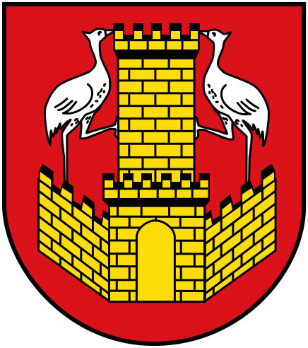
| Coat of arms | Deutsch: Gemeinde Kranenburg English: Municipality of Kranenburg Français : Municipalité de Kranenburg |
|||
| Blazon | Deutsch: „In Rot eine gezinnte goldene (gelbe) Stadtmauer mit einem goldenen (gelben) Torturm, auf der je ein silberner (weißer) Kranich, einander zugewendet und ein Bein gegen den Turm gestellt.“
Das Wappen ist "redend" und entstammt einem alten Stadt- und Schöffensiegel der ehemaligen mittelalterlichen Stadt im Kranichenbruch (Stadtrechte von ca. 1290-1800). English: „Gules, an embattled wall Or with a tower Or; thereupon turned towards each other two cranes Argent placing a leg against the tower.“
The arms were officially granted on July 28, 1972. The arms are based on the old seal of Kranenburg, known since the 13th century. The arms are canting, Kranenburg meaning castle of the cranes. None of the 4 added municipalities in 1969 had their own arms, so the arms were not changed after the merger. |
|||
| Blazon reference | Deutsch: § 2 der Hauptsatzung der Gemeinde Kranenburg |
|||
| Date | 28 July 1972 | |||
| Artist | Walther Bergmann
|
|||
| Source |
|
|||
| Permission (Reusing this file) |
|
|||
| Other versions |
This file was derived from: Wappen Kranenburg (Niederrhein).jpg: .jpg) |

This W3C-unspecified vector image was created with Inkscape .
File history
Click on a date/time to view the file as it appeared at that time.
| Date/Time | Thumbnail | Dimensions | User | Comment | |
|---|---|---|---|---|---|
| current | 21:16, 24 August 2013 | | 436 × 492 (12 KB) | Jürgen Krause (talk | contribs) | little corrections |
| 19:58, 24 August 2013 |  | 436 × 492 (12 KB) | Jürgen Krause (talk | contribs) | purged and resized - FIAV colours | |
| 07:37, 25 December 2008 |  | 750 × 825 (41 KB) | BetacommandBot (talk | contribs) | move approved by: User:ChristianBier This image was moved from File:Wapen Kranenborg, Nedderrhien.svg {{Information |Description= {{nds|Wapen vun de Gemeen Kranenburg in Noordrhien-Westfalen, Düütschland.}} {{de|Wappen der Gemeinde Kranenbur |
You cannot overwrite this file.
File usage on Commons
The following 28 pages use this file:
- Kreis Kleve
- File:Banner Kranenburg.svg
- File:DEU Kranenburg (Niederrhein) COA.svg
- File:Siegel Kranenburg.svg
- File:Wappen Kranenburg (Niederrhein).jpg
- File:Wappen Kranenburg (Niederrhein).svg (file redirect)
- Template:Districts of Kranenburg
- Template:Kranenburgdecade
- Template:Kranenburgyear
- Category:2018 in Kranenburg
- Category:2020 in Kranenburg
- Category:2021 in Kranenburg
- Category:2022 in Kranenburg
- Category:2023 in Kranenburg
- Category:Culture of Kranenburg
- Category:Frasselt
- Category:Geography of Kranenburg
- Category:Grafwegen
- Category:Kranenburg
- Category:Kranenburg in the 2010s
- Category:Kranenburg in the 2020s
- Category:Kranenburg in the 21st century
- Category:Mehr (Kranenburg)
- Category:Niel (Kranenburg)
- Category:Nütterden
- Category:Schottheide
- Category:Wyler (Kranenburg)
- Category:Zyfflich
_COA.svg)
.svg&redirect=no)
File usage on other wikis
The following other wikis use this file:
- Usage on ar.wikipedia.org
- Usage on arz.wikipedia.org
- Usage on be.wikipedia.org
- Usage on ceb.wikipedia.org
- Usage on ce.wikipedia.org
- Usage on de.wikipedia.org
- Kranenburg (Niederrhein)
- Nütterden
- Niel (Kranenburg)
- Mehr (Kranenburg)
- Liste der Wappen im Kreis Kleve
- Wyler (Kranenburg)
- Frasselt
- Schottheide
- Grafwegen
- Zyfflich
- Vorlage:Navigationsleiste Ortsteile von Kranenburg
- Grenze zwischen Deutschland und den Niederlanden
- Benutzer:Dat doris/Liste der Naturdenkmale im Reichswald
- Liste der Bodendenkmäler in Kranenburg (Niederrhein)
- Vorlage:Navigationsleiste Naturschutzgebiete in Kranenburg
- Naturschutzgebiet Hingstberg
- Usage on en.wikipedia.org
- Usage on eo.wikipedia.org
- Usage on es.wikipedia.org
- Usage on eu.wikipedia.org
- Usage on fa.wikipedia.org
- Usage on fr.wikipedia.org
- Usage on hu.wikipedia.org
- Usage on it.wikipedia.org
- Usage on kk.wikipedia.org
- Usage on ku.wikipedia.org
- Usage on li.wikipedia.org
- Usage on nds.wikipedia.org
- Usage on nl.wikipedia.org
- Usage on pl.wikipedia.org
- Usage on pt.wikipedia.org
- Usage on ro.wikipedia.org
- Usage on ru.wikipedia.org
- Usage on sh.wikipedia.org
View more global usage of this file.
_COA.svg)
_COA.svg&oldid=873260422)