File:Daedelus comparison, remote sensing in precision farming (rotated).jpg
Size of this preview: 800 × 489 pixels. Other resolutions: 320 × 196 pixels | 640 × 391 pixels | 883 × 540 pixels.
Original file (883 × 540 pixels, file size: 169 KB, MIME type: image/jpeg)
Captions
Captions
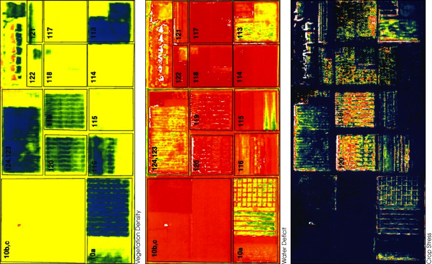
From L-R: vegetation density (blue is highest, red lowest); soil humidity (red is driest, blue wettest); crop stress (red indicates the most stressed, blue the healthiest crops. Note that fields 119 & 120 were due for irrigation the following day)
Summary edit
.jpg&action=edit§ion=1)
| Description |
English: Rotated version of  |
| Date | |
| Source |
|
| Author | Susan Moran, Landsat 7 Science Team and USDA Agricultural Research Service (U.S. Government work) |
| Other versions |
|
Licensing edit
.jpg&action=edit§ion=2)
| This file is in the public domain in the United States because it was solely created by NASA. NASA copyright policy states that "NASA material is not protected by copyright unless noted". (See Template:PD-USGov, NASA copyright policy page or JPL Image Use Policy.) | ||
 |
Warnings:
|
File history
Click on a date/time to view the file as it appeared at that time.
| Date/Time | Thumbnail | Dimensions | User | Comment | |
|---|---|---|---|---|---|
| current | 12:03, 16 August 2012 | | 883 × 540 (169 KB) | Tony Mach (talk | contribs) |
You cannot overwrite this file.
File usage on Commons
The following page uses this file:
File usage on other wikis
The following other wikis use this file:
- Usage on ckb.wikipedia.org
- Usage on en.wikipedia.org
- Usage on fa.wikipedia.org
.jpg&oldid=819168547)