File:Danes' Dyke reaches the sea - geograph.org.uk - 606564.jpg
No higher resolution available.
Danes'_Dyke_reaches_the_sea_-_geograph.org.uk_-_606564.jpg (640 × 480 pixels, file size: 68 KB, MIME type: image/jpeg)
Captions
Captions
Add a one-line explanation of what this file represents
Summary edit
| Description |
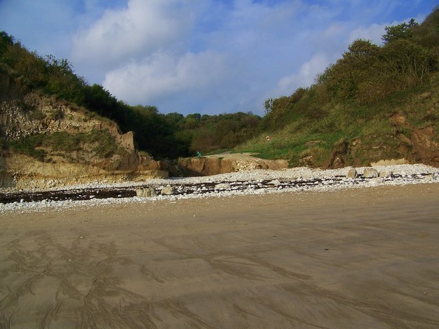
English: Danes' Dyke reaches the sea, Sewerby, East Riding of Yorkshire, England. Despite its name the ditch was dug long before the Danes occupied this coast in the 9th century. Flint arrowheads found on the site suggest a date before the Iron Age, making the dyke at least 2,000 years old. The Dyke exits into Bridlington Bay. |
| Date | |
| Source | From geograph.org.uk |
| Author | Trish Steel |
| Permission (Reusing this file) |
Creative Commons Attribution Share-alike license 2.0 |
| Camera location | | View this and other nearby images on: OpenStreetMap |
|---|
_heading:337.00&language=en)
| Object location | | View this and other nearby images on: OpenStreetMap |
|---|
_heading:337.00&language=en)
Licensing edit

|
This image was taken from the Geograph project collection. See this photograph's page on the Geograph website for the photographer's contact details. The copyright on this image is owned by Trish Steel and is licensed for reuse under the Creative Commons Attribution-ShareAlike 2.0 license.
|
This file is licensed under the Creative Commons Attribution-Share Alike 2.0 Generic license.
Attribution: Trish Steel
- You are free:
- to share – to copy, distribute and transmit the work
- to remix – to adapt the work
- Under the following conditions:
- attribution – You must give appropriate credit, provide a link to the license, and indicate if changes were made. You may do so in any reasonable manner, but not in any way that suggests the licensor endorses you or your use.
- share alike – If you remix, transform, or build upon the material, you must distribute your contributions under the same or compatible license as the original.
File history
Click on a date/time to view the file as it appeared at that time.
| Date/Time | Thumbnail | Dimensions | User | Comment | |
|---|---|---|---|---|---|
| current | 22:53, 6 February 2011 | | 640 × 480 (68 KB) | GeographBot (talk | contribs) | == {{int:filedesc}} == {{Information |description={{en|1=Danes' Dyke reaches the sea Despite its name the ditch was dug long before the Danes occupied this coast in the 9th century. Flint arrowheads found on the site suggest a date before the Iron Age, m |
You cannot overwrite this file.
File usage on Commons
There are no pages that use this file.