File:Danielsveita 2 (1984) (3903465162).jpg

Original file (5,408 × 3,978 pixels, file size: 4.15 MB, MIME type: image/jpeg)
Captions
Captions
Summary edit
_(3903465162).jpg&action=edit§ion=1)
| Description |
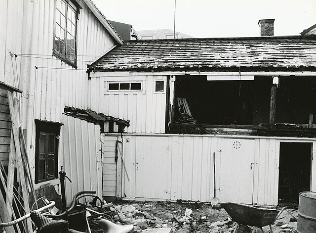
Format: Fotopositiv Dato / Date: 1984 Fotograf / Photographer: Ukjent Sted / Place: Danielsveita 2, Trondheim Oppdatert / Update: 07.03.2016 [format, sjekket katalognr.] Eier / Owner Institution: Trondheim byarkiv, The Municipal Archives of Trondheim Arkivreferanse / Archive reference: Tor.H40.B06.F0307 [T0609] Merknad: Danielsveita går fra Erling Skakkes gate og nordover til Kongens gate. Veita har også vært kalt Davidsveita. Den ble delvis gjenbygd av Trondheim Torg i 1967. Husene i veita er fra 1860-årene. Ved Trondhjems kommunale folketelling i 1925 opplyses følgende om eiere og beboere i Danielsveita 2: Eier: Ugift gårdeier Nicoline Edler, f. 09.10.1862 i Trondhjem. Husstander: - 1.) Ugift gårdeier Andrea Nikoline Edler, f. 09.10.1862 i Trondhjem. 1 etasje, 2 borom, delt kjøkken. Husleie 34 kroner. - 2.) Ugift arbeiderske Serine Elise Berge, f. 05.05.1873 i Rissa. 1 etasje, 2 borom, 1 kjøkken. Husleie 34 kroner. - Ugift ekspeditrise Gudrun Josefine Rønning, født 11.02.1884 i Trondhjem. - 3.) Gift gartner Jakob Theodor Edler, født 11.02.1872 i Trondhjem. 2 etasje, 1 borom, delt kjøkken. Husleie 15 kroner. - Gift husmor Inga Nekoline Edler, født 17.06.1882 på Frosta. - 4.) Ugift assistent ved Byens barneasyl i Sverres gate 16 B, Alchine Aune født 01.04.1859 i Trondhjem. 2 etasje, 2 borom, 1 kjøkken. Husleie 38 kroner. - 5.) Ugift forsikringsinspektør Einar J. Aas, født 22.09.1900 på Vestnes. 2 etasje, 2 borom, 1 kjøkken. Husleie 41 kroner. - Enke og oppsynsdame Margrethe Severine Holthe, født 01.05.1881 i Mo i Rana. - Ugift butikkdame Margit Henriethe Holthe, født 06.09.1901 i Mo i Rana. - Skoleelev ved Kalvskinnet skole, Harald Holthe født 05.02.1914 i Trondhjem. |
| Date | |
| Source | Danielsveita 2 (1984) |
| Author | Municipal Archives of Trondheim from Trondheim, Norway |
| Camera location | | View this and other nearby images on: OpenStreetMap |
|---|
_(3903465162).jpg¶ms=063.429223_N_0010.393538_E_globe:Earth_type:camera_source:Flickr_&language=en)
Licensing edit
_(3903465162).jpg&action=edit§ion=2)
- You are free:
- to share – to copy, distribute and transmit the work
- to remix – to adapt the work
- Under the following conditions:
- attribution – You must give appropriate credit, provide a link to the license, and indicate if changes were made. You may do so in any reasonable manner, but not in any way that suggests the licensor endorses you or your use.
| This image was originally posted to Flickr by Trondheim byarkiv at https://flickr.com/photos/29160242@N08/3903465162 (archive). It was reviewed on 27 February 2018 by FlickreviewR 2 and was confirmed to be licensed under the terms of the cc-by-2.0. |
File history
Click on a date/time to view the file as it appeared at that time.
| Date/Time | Thumbnail | Dimensions | User | Comment | |
|---|---|---|---|---|---|
| current | 21:28, 27 February 2018 | | 5,408 × 3,978 (4.15 MB) | Artix Kreiger 2 (talk | contribs) | Transferred from Flickr via Flickr2Commons |
You cannot overwrite this file.
File usage on Commons
There are no pages that use this file.
_(3903465162).jpg&oldid=455589831)