File:Danske-amter-1793-1970.png
No higher resolution available.
Danske-amter-1793-1970.png (400 × 479 pixels, file size: 11 KB, MIME type: image/png)
Captions
Captions
Add a one-line explanation of what this file represents
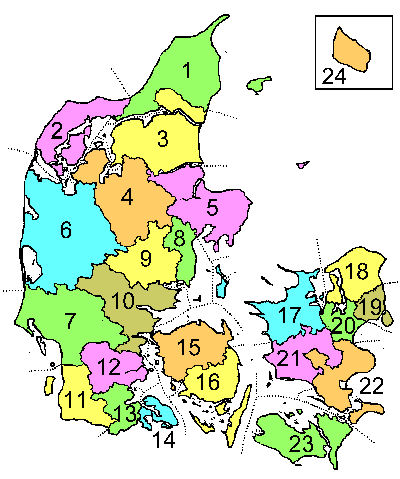
- Description: This is a map showing Danish counties as they were during the period 1793-1970.
- Caption: The names of the counties are listed at da:Danmarks amter (1793-1970)
- Author: The map was drawn by Lars Helbo
| I, the copyright holder of this work, release this work into the public domain. This applies worldwide. In some countries this may not be legally possible; if so: I grant anyone the right to use this work for any purpose, without any conditions, unless such conditions are required by law. |
File history
Click on a date/time to view the file as it appeared at that time.
| Date/Time | Thumbnail | Dimensions | User | Comment | |
|---|---|---|---|---|---|
| current | 14:41, 28 July 2005 | | 400 × 479 (11 KB) | Lars Helbo~commonswiki (talk | contribs) | This is a map showing Danish counties as they were during the period 1793-1970. The map was drawn by Lars Helbo {{PD}} |
You cannot overwrite this file.
File usage on Commons
The following 2 pages use this file:
File usage on other wikis
The following other wikis use this file:
- Usage on da.wikipedia.org
- Usage on de.wikipedia.org
- Usage on en.wikipedia.org
- Usage on fi.wikipedia.org
- Usage on ko.wikipedia.org
- Usage on nl.wikipedia.org
- Usage on no.wikipedia.org
- Usage on sv.wikipedia.org