File:Daubenhorn Panorama.jpg

Size of this preview: 798 × 137 pixels. Other resolutions: 320 × 55 pixels | 640 × 110 pixels | 1,024 × 176 pixels | 1,280 × 220 pixels | 2,560 × 440 pixels | 21,404 × 3,675 pixels.
Original file (21,404 × 3,675 pixels, file size: 46.05 MB, MIME type: image/jpeg)
Captions
Captions
Add a one-line explanation of what this file represents
| Warning | The original file is very high-resolution. It might not load properly or could cause your browser to freeze when opened at full size. |
|---|
Summary edit
| Description |
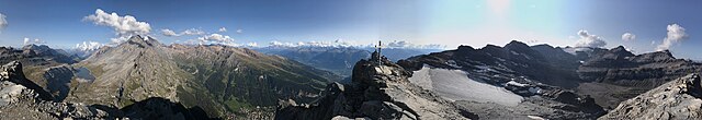
English: 360° panorama from Daubenhorn (Leukerbad, Valais, Switzerland, Bernese Alps). A view to Wildstrubel mountain Grossstrubel and Stäghore.
Deutsch: 360°-Panorama vom Daubenhorn (Leukerbad, Wallis, Schweiz). Eines der wenigen Bilder des Gipfels Grossstrubel mit der Südostseite in ganzer Pracht des Felsgipfels. Weiter östlich das Steghorn. Unten der Daubensee am Gemmipass oberhalb von Leukerbad mit den Gemmi-Plattenhörnern (von oben gesehen) und dem Rinderhorn. Entfernter die Loner (Lohner) weiter im Norden schon fast bei Kandersteg.
Rumantsch: Vista panoramica da 360° digl Daubenhorn (Leukerbad, Valleis, Svizra)
Italiano: Vista panoramica di 360° dal Daubenhorn (Leukerbad, Vallese, Svizzera) |
||
| Date | |||
| Source |
Own work
|
||
| Author | Capricorn4049 | ||
| Permission (Reusing this file) |
|

| Camera location | | View this and other nearby images on: OpenStreetMap |
|---|
| 360° | View in 360° panoramic viewer
|
|---|
| Warning | The original file is very high-resolution. It might not load properly or could cause your browser to freeze when opened at full size. |
|---|
|
|
Further panoramas can be found here. |
Licensing edit
I, the copyright holder of this work, hereby publish it under the following license:
This file is licensed under the Creative Commons Attribution-Share Alike 4.0 International license.
- You are free:
- to share – to copy, distribute and transmit the work
- to remix – to adapt the work
- Under the following conditions:
- attribution – You must give appropriate credit, provide a link to the license, and indicate if changes were made. You may do so in any reasonable manner, but not in any way that suggests the licensor endorses you or your use.
- share alike – If you remix, transform, or build upon the material, you must distribute your contributions under the same or compatible license as the original.
| Annotations | This image is annotated: View the annotations at Commons |
File history
Click on a date/time to view the file as it appeared at that time.
| Date/Time | Thumbnail | Dimensions | User | Comment | |
|---|---|---|---|---|---|
| current | 00:16, 28 September 2020 | 21,404 × 3,675 (46.05 MB) | Capricorn4049 (talk | contribs) | Uploaded own work with UploadWizard |
You cannot overwrite this file.
File usage on Commons
The following 3 pages use this file:
- Daubensee
- File:Dauberhorn Panorama.jpg (file redirect)
- Category:Daubenhorn
File usage on other wikis
The following other wikis use this file:
- Usage on de.wikipedia.org
- Usage on www.wikidata.org