File:Dawson 1882 Coal mine point reefs map.png
Size of this preview: 800 × 567 pixels. Other resolutions: 320 × 227 pixels | 640 × 454 pixels | 1,024 × 726 pixels | 1,280 × 907 pixels | 2,560 × 1,814 pixels | 3,000 × 2,126 pixels.
Original file (3,000 × 2,126 pixels, file size: 2.03 MB, MIME type: image/png)
Captions
Captions
Add a one-line explanation of what this file represents
Summary
edit
| Description |
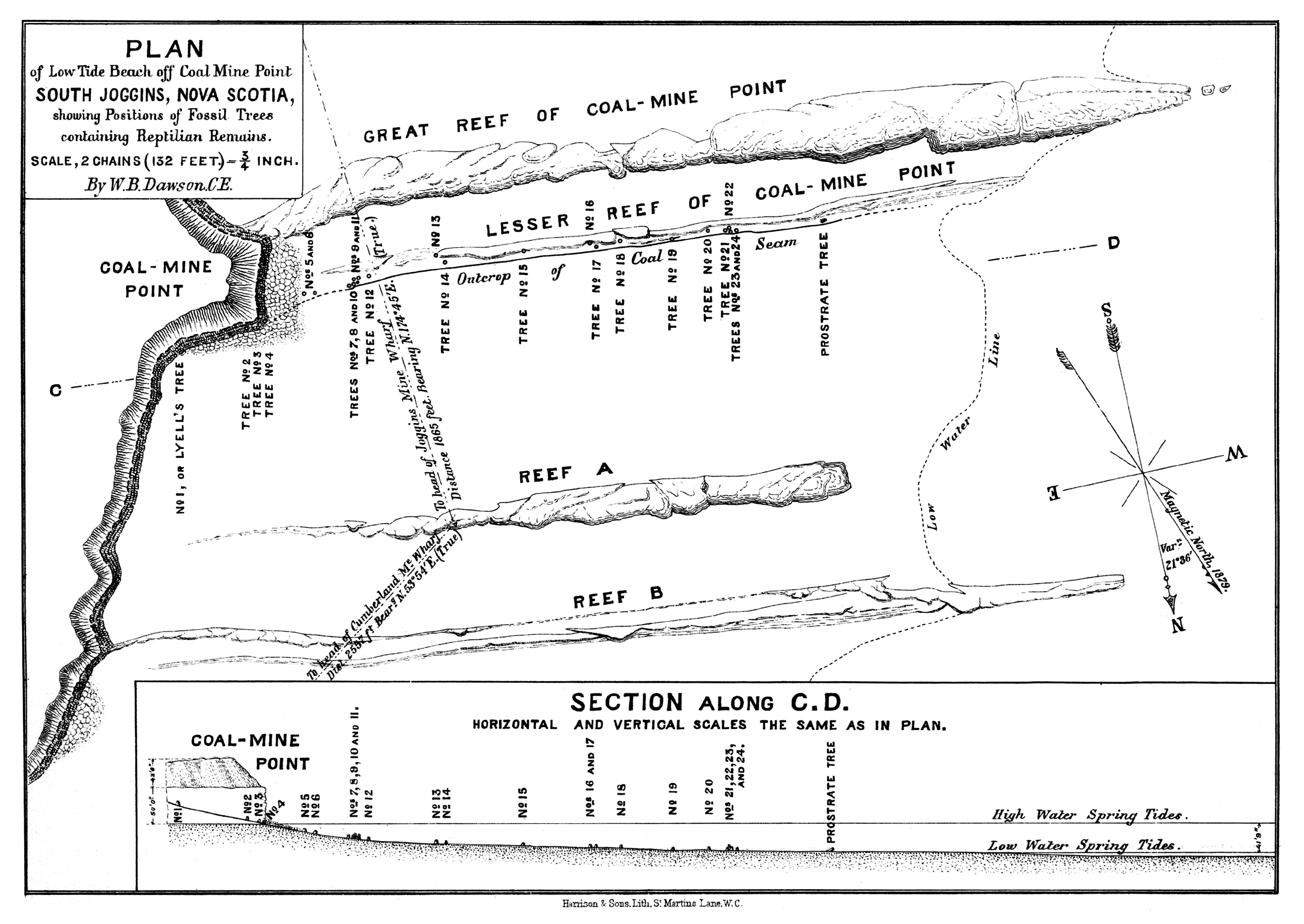
English: Historical map of the Joggins sea cliff at Coal Mine Point (Hardscrabble Point), Nova Scotia, including low ridges (“reefs”) which extend from the cliff front into the tidal flat of the Chignecto Bay. These “reefs” are erosional remnants representing those beds within the sedimentary succession of the Joggins Formation which are most resistant to erosion (at the Joggins Cliffs in most cases, as well as at Coal Mine Point, these are sandstone beds). From the ridge labelled as “Lesser Reef” in the map, John William Dawson and allies recovered 25 fossil tree stumps of lycopod trees in 1877, 15 of which contained fossil remains of land vertebrates (tetrapods).
Deutsch: Historische Karte der Joggins-Kliffküste bei Coal Mine Point (Hardscrabble Point), Nova Scotia, einschließlich der niedrigen Felsenrippen („Riffe“), die sich von der Klifffront in das Watt der Chignecto Bay erstrecken. Bei diesen „Riffen“ handelt es sich um Erosionsreste, die die erosionsresistentesten Schichten in der Abfolge der Joggins-Formation repräsentieren (in den meisten Fällen, so auch am Coal Mine Point, sind dies Sandsteinschichten). An der als „Lesser Reef“ beschrifteten Rippe gruben John William Dawson und Mitarbeiter im Jahre 1877 25 fossile Baumstümpfe von Bärlappbäumen aus, von denen 15 Überreste von Landwirbeltieren (Tetrapoden) bargen. |
| Date | |
| Source | On the Results of Recent Explorations of Erect Trees Containing Animal Remains in the Coal-Formation of Nova Scotia. Philosophical Transactions of the Royal Society of London. Vol. 173, plate 47 |
| Author | John William Dawson (1820-1899) |
Licensing
edit
|
This work is in the public domain in its country of origin and other countries and areas where the copyright term is the author's life plus 70 years or fewer. | |
| This file has been identified as being free of known restrictions under copyright law, including all related and neighboring rights. | |
This media file is in the public domain in the United States. This applies to U.S. works where the copyright has expired, often because its first publication occurred prior to January 1, 1929, and if not then due to lack of notice or renewal. See this page for further explanation.
|
 | |
 |
File history
Click on a date/time to view the file as it appeared at that time.
| Date/Time | Thumbnail | Dimensions | User | Comment | |
|---|---|---|---|---|---|
| current | 19:39, 13 April 2014 | | 3,000 × 2,126 (2.03 MB) | Gretarsson (talk | contribs) | {{Information |Description ={{en|1=Historical map of the Joggins sea cliff at Coal Mine Point (Hardscrabble Point), Nova Scotia, including low ridges (reefs) which extend from the cliff front into the tidal flat of the Chignecto Bay. These reefs are... |
You cannot overwrite this file.
File usage on Commons
There are no pages that use this file.
File usage on other wikis
The following other wikis use this file:
- Usage on de.wikipedia.org