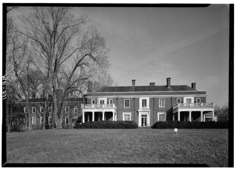
File:December 1971 WEST ELEVATION - Oxon Hill Manor, 6701 Oxon Hill Road, Oxon Hill, Prince George's County, MD HABS MD,17-OXHI,1-3.tif
Size of this JPG preview of this TIF file: 800 × 574 pixels. Other resolutions: 320 × 230 pixels | 640 × 459 pixels | 1,024 × 734 pixels | 1,280 × 918 pixels | 2,560 × 1,836 pixels | 5,000 × 3,586 pixels.
Original file (5,000 × 3,586 pixels, file size: 17.1 MB, MIME type: image/tiff)
Captions
Captions
Add a one-line explanation of what this file represents
Summary edit
| December 1971 WEST ELEVATION - Oxon Hill Manor, 6701 Oxon Hill Road, Oxon Hill, Prince George's County, MD | ||||
|---|---|---|---|---|
| Photographer |
Boucher, Jack E. |
|||
| Title |
December 1971 WEST ELEVATION - Oxon Hill Manor, 6701 Oxon Hill Road, Oxon Hill, Prince George's County, MD |
|||
| Description |
de Sibour, Jules Henri; Wells, Summer; Myers, Denys Peter, historian; Miller, Hugh C, historian; Boucher, Jack E, photographer |
|||
| Depicted place | Maryland; Prince George's County; Oxon Hill | |||
| Date | Documentation compiled after 1933 | |||
| Dimensions | 5 x 7 in. | |||
| Current location |
Library of Congress Prints and Photographs Division Washington, D.C. 20540 USA http://hdl.loc.gov/loc.pnp/pp.print |
|||
| Accession number |
HABS MD,17-OXHI,1-3 |
|||
| Credit line |
|
|||
| Notes |
|
|||
| Source | https://www.loc.gov/pictures/item/md0548.photos.083504p | |||
| Permission (Reusing this file) |
|
|||

| Object location | | View this and other nearby images on: OpenStreetMap |
|---|
File history
Click on a date/time to view the file as it appeared at that time.
| Date/Time | Thumbnail | Dimensions | User | Comment | |
|---|---|---|---|---|---|
| current | 23:58, 21 July 2014 |  | 5,000 × 3,586 (17.1 MB) | Fæ (talk | contribs) | GWToolset: Creating mediafile for Fæ. HABS 21 July 2014 (1601:1800) |
You cannot overwrite this file.
File usage on Commons
The following page uses this file: