File:December 1992 GENERAL VIEW OF BUILDING S84 FACING NORTHEAST FROM AIRFIELD - U.S. Naval Base, Pearl Harbor, Operations Building, Ford Island, Enterprise Street near Intrepid HABS HI,2-PEHA,18-8.tif

Size of this JPG preview of this TIF file: 476 × 599 pixels. Other resolutions: 191 × 240 pixels | 381 × 480 pixels | 610 × 768 pixels | 814 × 1,024 pixels | 1,627 × 2,048 pixels | 3,973 × 5,000 pixels.
Original file (3,973 × 5,000 pixels, file size: 18.95 MB, MIME type: image/tiff)
Captions
Captions
Add a one-line explanation of what this file represents
Summary edit
| December 1992 GENERAL VIEW OF BUILDING S84 FACING NORTHEAST FROM AIRFIELD - U.S. Naval Base, Pearl Harbor, Operations Building, Ford Island, Enterprise Street near Intrepid Boulevard, Pearl City, Honolulu County, HI | ||||
|---|---|---|---|---|
| Title |
December 1992 GENERAL VIEW OF BUILDING S84 FACING NORTHEAST FROM AIRFIELD - U.S. Naval Base, Pearl Harbor, Operations Building, Ford Island, Enterprise Street near Intrepid Boulevard, Pearl City, Honolulu County, HI |
|||
| Depicted place | Hawaii; Honolulu County; Pearl City | |||
| Date | Documentation compiled after 1933 | |||
| Dimensions | 4 x 5 in. | |||
| Current location |
Library of Congress Prints and Photographs Division Washington, D.C. 20540 USA http://hdl.loc.gov/loc.pnp/pp.print |
|||
| Accession number |
HABS HI,2-PEHA,18-8 |
|||
| Credit line |
|
|||
| Notes |
|
|||
| References |
|
|||
| Source | https://www.loc.gov/pictures/item/hi0229.photos.048209p | |||
| Permission (Reusing this file) |
|
|||

| Object location | | View this and other nearby images on: OpenStreetMap |
|---|
File history
Click on a date/time to view the file as it appeared at that time.
| Date/Time | Thumbnail | Dimensions | User | Comment | |
|---|---|---|---|---|---|
| current | 17:12, 11 July 2014 | 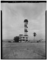 | 3,973 × 5,000 (18.95 MB) | Fæ (talk | contribs) | GWToolset: Creating mediafile for Fæ. HABS 11 July 2014 (1001:1200) |
You cannot overwrite this file.
File usage on Commons
The following page uses this file: