File:Decision Support System for John Day Reservoir.jpg
No higher resolution available.
Decision_Support_System_for_John_Day_Reservoir.jpg (477 × 364 pixels, file size: 178 KB, MIME type: image/jpeg)
Captions
Captions
Add a one-line explanation of what this file represents
Summary edit
| Description |
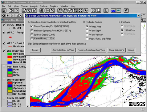
English: This set of tools, in conjunction with 2-dimensional hydraulic modeling, is being used to estimate the effects of reservoir level and water discharge fluctuations on aquatic and terrestrial habitats in John Day Reservoir. Different scenarios being studied now range from typical reservoir levels at high and low discharges to a simulation of what things might be like if the river were to return to natural conditions |
| Date | Retrieved June 17 2009. |
| Source | http://wfrc.usgs.gov/research/geospatial%20studies/STGeospat4.htm ...returns HTTP status 404. The most recent non-404 snapshot of this page from archive.org is: https://web.archive.org/web/20100527105316/http://wfrc.usgs.gov/research/geospatial%20studies/STGeospat4.htm |
| Author | USGS: Project contact Michael J. Parsley, U.S. Geological Survey |
Licensing edit
This image is in the public domain in the United States because it only contains materials that originally came from the United States Geological Survey, an agency of the United States Department of the Interior. For more information, see the official USGS copyright policy.
|
File history
Click on a date/time to view the file as it appeared at that time.
| Date/Time | Thumbnail | Dimensions | User | Comment | |
|---|---|---|---|---|---|
| current | 11:40, 17 June 2009 | | 477 × 364 (178 KB) | Mdd (talk | contribs) | {{Information |Description={{en|1=This set of tools, in conjunction with 2-dimensional hydraulic modeling, is being used to estimate the effects of reservoir level and water discharge fluctuations on aquatic and terrestrial habitats in John Day Reservoir. |
You cannot overwrite this file.
File usage on Commons
The following page uses this file:
File usage on other wikis
The following other wikis use this file:
- Usage on ar.wikipedia.org
- Usage on el.wikipedia.org
- Usage on en.wikipedia.org
- Usage on es.wikipedia.org
- Usage on fa.wikipedia.org
- Usage on fr.wikipedia.org
- Usage on ja.wikipedia.org
- Usage on ko.wikipedia.org
- Usage on sr.wikipedia.org
- Usage on tr.wikipedia.org
- Usage on uk.wikipedia.org
- Usage on www.wikidata.org