File:Demonstration of the Tributaries of the São Francisco River, Minas Gerais WDL887.png

Size of this preview: 748 × 599 pixels. Other resolutions: 300 × 240 pixels | 599 × 480 pixels | 959 × 768 pixels | 1,278 × 1,024 pixels.
Original file (1,278 × 1,024 pixels, file size: 2.56 MB, MIME type: image/png)
File information
Structured data
Captions
Captions
Add a one-line explanation of what this file represents
Summary edit
| Title |
Русский: Карта притоков реки Сан-Франциско, Минас-Жерайс
Français : Présentation des affluents du fleuve São Francisco, dans le Minas Gerais
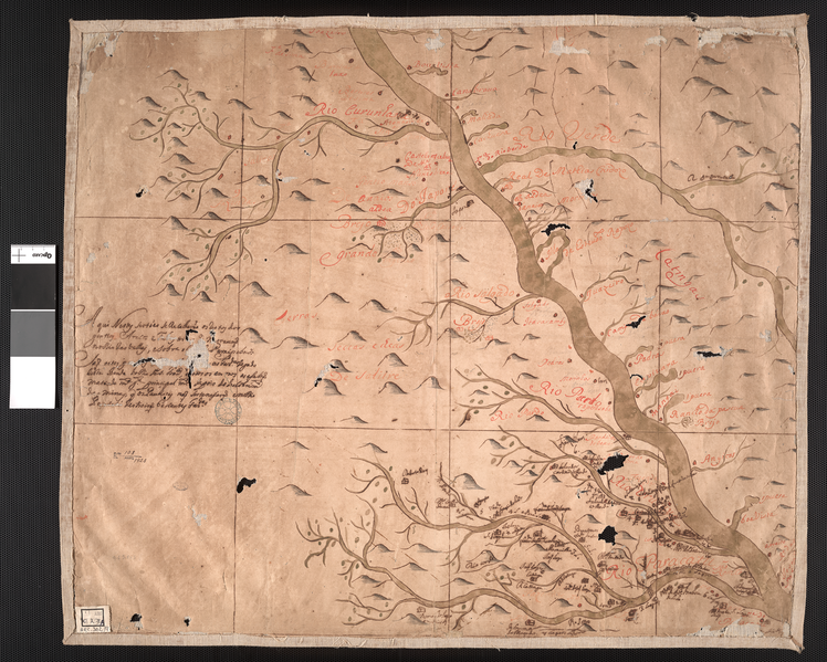
English: Demonstration of the Tributaries of the São Francisco River, Minas Gerais
中文:表明了位于米纳斯吉拉斯的圣弗朗西斯科河的各条支流
Português: Demonstração dos Afluentes do Rio São Francisco, Minas Gerais
العربية: بيان روافد نهر ساو فرانسيسكو، ميناس جيرايس
Español: Representación de los afluentes del río São Francisco, Minas Gerais |
| Description |
Русский: На данной рукописной карте, составленной неизвестным картографом начале XVIII века, изображены притоки реки Сан-Франсиску в бразильском штате Минас-Жерайс. Водная система реки Сан-Франсиску, в которую входят 168 притоков, является четвертой по величине речной системой в Южной Америке. с
Бразилия -- История -- Колониальный период, 1500-1822 гг.; Колониальные экспедиции; Реки; Река Сан-Франсиску; Тропы; Тропы Français : Cette carte manuscrite coloriée à la main, dressée par un cartographe inconnu au début du XVIIIe siècle, montre les affluents du fleuve São Francisco au Brésil dans l'État du Minas Gerais. Le réseau fluvial du São Francisco, qui comprend 168 affluents, est le quatrième plus grand système fluvial d'Amérique du sud. Au début du XVIIIe siècle, les Portugais ont lancé de nombreuses expéditions du São Francisco et de ses affluents à la recherche d'or, d'argent et de diamants.
Brésil -- Histoire -- Période Coloniale, 1500-1822; Expéditions coloniales; Rivières, fleuves et cours d'eau; Fleuve San Francisco; Voies ferrées; Pistes, chemins English: This hand-colored manuscript map, made by an unknown cartographer sometime in the early 18th century, shows the tributaries of the São Francisco River in Brazil’s Minas Gerais state. The São Francisco River system, which includes 168 tributaries, is the fourth-largest river system in South America. In the early 18th century, the Portuguese sent numerous expeditions up the São Francisco and its tributaries in search of gold, silver, and diamonds.
Brazil -- History -- Colonial Period, 1500-1822; Colonial expeditions; Rivers; São Francisco River; Tracks; Trails 中文:这幅手绘彩色地图,作者不详,约于 18 世纪早期绘制,描绘的是巴西米纳斯吉拉斯州的圣弗朗西斯科河支流。 圣弗朗西斯科河系包括 168 个支流,是南美洲第四大河系之一。 18 世纪早期,葡萄牙人数次前往圣弗朗西斯科河及其支流探险,寻找黄金、白银和钻石。
巴西-历史-殖民统治时期,1500 年-1822 年; 殖民远征; 河流; 圣弗朗西斯科河; 足迹; 踪迹 Português: Este mapa manuscrito, colorido à mão, feito por um cartógrafo desconhecido no início do século XVIII, mostra os afluentes do Rio São Francisco, no estado brasileiro de Minas Gerais. O sistema do Rio São Francisco, que inclui 168 afluentes, é o quarto maior sistema fluvial da América do Sul. No século XVIII, os portugueses enviaram numerosas expedições subindo o São Francisco e seus afluentes, em busca de ouro, prata e diamantes.
Brasil - História - Período Colonial, 1500-1822; Expedições coloniais; Rios; Rio São Francisco; Trilhas; Trilhos العربية: تظهر هذه الخريطة المخطوطة الملونة باليد، التي أعدها رسام خرائط مجهول في وقت ما في أوائل القرن الثمن عشر، روافد نهر ساو فرانسيسكو في ولاية ميناس جيرايس في البرازيل. ونظام نهر ساو فرانسيسكو، الذي يشمل 168 رافدًا، هو رابع أكبر نظام نهرى في أمريكا الجنوبية. وفي أوائل القرن الثامن عشر، أرسل البرتغاليون بعثات عديدة إلى أعلى ساو فرانسيسكو وروافده بحثا عن الذهب، والفضة، والماس.
البرازيل -- التاريخ -- الفترة الاستعمارية، 1500-1822; البعثات الاستكشافية الاستعمارية; الأنهار; نهر ساو فرانسيسكو; المسارات; الممرات Español: Este mapa manuscrito pintado a mano, realizado por un desconocido cartógrafo en algún momento en el siglo XVIII, muestra los afluentes del río São Francisco en Brasil en el estado de Minas Gerais. El sistema del río São Francisco, que incluye 168 afluentes, es el cuarto sistema de ríos más grande en América del Sur. A principios del siglo XVIII, los portugueses enviaron numerosas expediciones río arriba por el São Francisco y sus afluentes en busca de oro, plata y diamantes.
Brasil - Historia - Período colonial, 1500-1822; Expediciones coloniales; Ríos; Río São Francisco; Caminos; Senderos |
| Date |
between 1700 and 1799 date QS:P571,+1750-00-00T00:00:00Z/7,P1319,+1700-00-00T00:00:00Z/9,P1326,+1799-00-00T00:00:00Z/9 |
| Medium |
Русский: Карты
Français : Cartes
English: Maps
中文:地图
Português: Mapas
العربية: خرائط
Español: Mapas |
| Dimensions |
English: 1 manuscript map : color ; 35.5 x 67.5 centimeters |
| Collection |
Русский: Национальная библиотека Бразилии
Français : Bibliothèque nationale du Brésil
English: National Library of Brazil
中文:巴西国家图书馆
Português: Biblioteca Nacional do Brasil
العربية: مكتبة البرازيل الوطنية
Español: Biblioteca Nacional de Brasil |
| Place of creation |
Русский: Минас-Жерайс
Français : Minas Gerais
English: Minas Gerais
中文:米纳斯吉拉斯
Português: Minas Gerais
العربية: ميناس جيرايس
Español: Minas Gerais |
| Notes | Original language title: Demonstração dos afluentes do Rio São Francisco, em Minas Gerais |
| References | http://hdl.loc.gov/loc.wdl/brrjbn.887 |
| Source/Photographer |
|
Licensing edit
|
This is a faithful photographic reproduction of a two-dimensional, public domain work of art. The work of art itself is in the public domain for the following reason:
The official position taken by the Wikimedia Foundation is that "faithful reproductions of two-dimensional public domain works of art are public domain".
This photographic reproduction is therefore also considered to be in the public domain in the United States. In other jurisdictions, re-use of this content may be restricted; see Reuse of PD-Art photographs for details. | |||||
File history
Click on a date/time to view the file as it appeared at that time.
| Date/Time | Thumbnail | Dimensions | User | Comment | |
|---|---|---|---|---|---|
| current | 01:06, 12 March 2014 |  | 1,278 × 1,024 (2.56 MB) | Fæ (talk | contribs) | =={{int:filedesc}}== {{Artwork |artist = |author = |title ={{ru|1=Карта притоков реки Сан-Франциско, Минас-Жерайс}} {{fr|1=Présentation des affluents du fleuve São Francisco, dans le Minas Gerais}} {{en|1=Demon... |
You cannot overwrite this file.
File usage on Commons
The following page uses this file: