File:Dené-Yeniseian.svg

Size of this PNG preview of this SVG file: 800 × 465 pixels. Other resolutions: 320 × 186 pixels | 640 × 372 pixels | 1,024 × 595 pixels | 1,280 × 744 pixels | 2,560 × 1,489 pixels | 951 × 553 pixels.
Original file (SVG file, nominally 951 × 553 pixels, file size: 608 KB)
Captions
Captions
Add a one-line explanation of what this file represents
| Description |
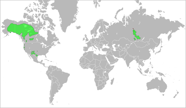
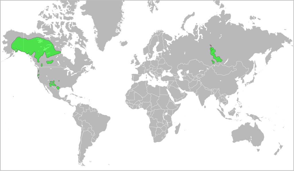
English: A map indicating the approximate distribution of the Dené-Yeniseian languages (green areas) in the XVII century. |
| Date | (UTC) |
| Source | |
| Author |
|
This file is licensed under the Creative Commons Attribution-Share Alike 3.0 Unported license.
- You are free:
- to share – to copy, distribute and transmit the work
- to remix – to adapt the work
- Under the following conditions:
- attribution – You must give appropriate credit, provide a link to the license, and indicate if changes were made. You may do so in any reasonable manner, but not in any way that suggests the licensor endorses you or your use.
- share alike – If you remix, transform, or build upon the material, you must distribute your contributions under the same or compatible license as the original.
Original upload log edit
This image is a derivative work of the following images:
- File:Yeniseian_map_XVII-XX.png licensed with Cc-by-2.5
- 2009-01-19T22:38:12Z 姫宮南 450x500 (31768 Bytes) {{Information |Description={{en|The map of distribution of [[:en:Yeniseian languages|]] (red) in the XVII century (approximate; hatching) and in the end of XX century (continuous background).}}{{ru|Карта распрос�
- File:Na-Dene_langs.png licensed with Cc-by-2.0
Uploaded with derivativeFX
File history
Click on a date/time to view the file as it appeared at that time.
| Date/Time | Thumbnail | Dimensions | User | Comment | |
|---|---|---|---|---|---|
| current | 14:17, 25 November 2016 | | 951 × 553 (608 KB) | Elevatorrailfan (talk | contribs) | No need not to include the borders of Europe. |
| 16:13, 24 May 2010 |  | 951 × 553 (548 KB) | Jon Harald Søby (talk | contribs) | Fixing background issues, removing whitespace | |
| 23:59, 2 March 2010 |  | 999 × 553 (636 KB) | Ryanaxp (talk | contribs) | Made all areas green, instead of green and red, to improve clarity | |
| 23:52, 2 March 2010 |  | 999 × 553 (556 KB) | Ryanaxp (talk | contribs) | {{Information |Description={{en|A map indicating the approximate distribution of the Dené-Yeniseian languages (red and green areas) in the XVII century.}} |Source=*File:Yeniseian_map_XVII-XX.png *[[:File:Na-Dene_la |
You cannot overwrite this file.
File usage on Commons
The following page uses this file:
File usage on other wikis
The following other wikis use this file:
- Usage on af.wikipedia.org
- Usage on ast.wikipedia.org
- Usage on ca.wikipedia.org
- Usage on el.wikipedia.org
- Usage on en.wikipedia.org
- Usage on es.wikipedia.org
- Usage on fi.wikipedia.org
- Usage on frr.wikipedia.org
- Usage on fr.wikipedia.org
- Usage on fy.wikipedia.org
- Usage on ja.wikipedia.org
- Usage on lez.wikipedia.org
- Usage on lt.wikipedia.org
- Usage on mg.wikipedia.org
- Usage on mrj.wikipedia.org
- Usage on nl.wikipedia.org
- Usage on no.wikipedia.org
- Usage on pl.wikipedia.org
- Usage on sr.wikipedia.org
- Usage on tr.wikipedia.org
- Usage on ur.wikipedia.org
- Usage on zh.wikipedia.org