File:Dengelstein (4).jpg
Size of this preview: 800 × 536 pixels. Other resolutions: 320 × 214 pixels | 640 × 429 pixels | 1,024 × 686 pixels | 1,280 × 857 pixels | 2,560 × 1,715 pixels | 3,690 × 2,472 pixels.
Original file (3,690 × 2,472 pixels, file size: 1.49 MB, MIME type: image/jpeg)
File information
Structured data
Captions
DescriptionDengelstein (4).jpg | |
Date | |
Source | Own work |
Author | © 1971markus (☠): ⇒ Laberkasten ... |
Permission (Reusing this file) |
© 1971markus, the copyright holder of this work, hereby publishes it under the following license: This file is licensed under the Creative Commons Attribution-Share Alike 3.0 Germany license. Attribution: © 1971markus
|
File history
Click on a date/time to view the file as it appeared at that time.
Date/Time | Thumbnail | Dimensions | User | Comment | |
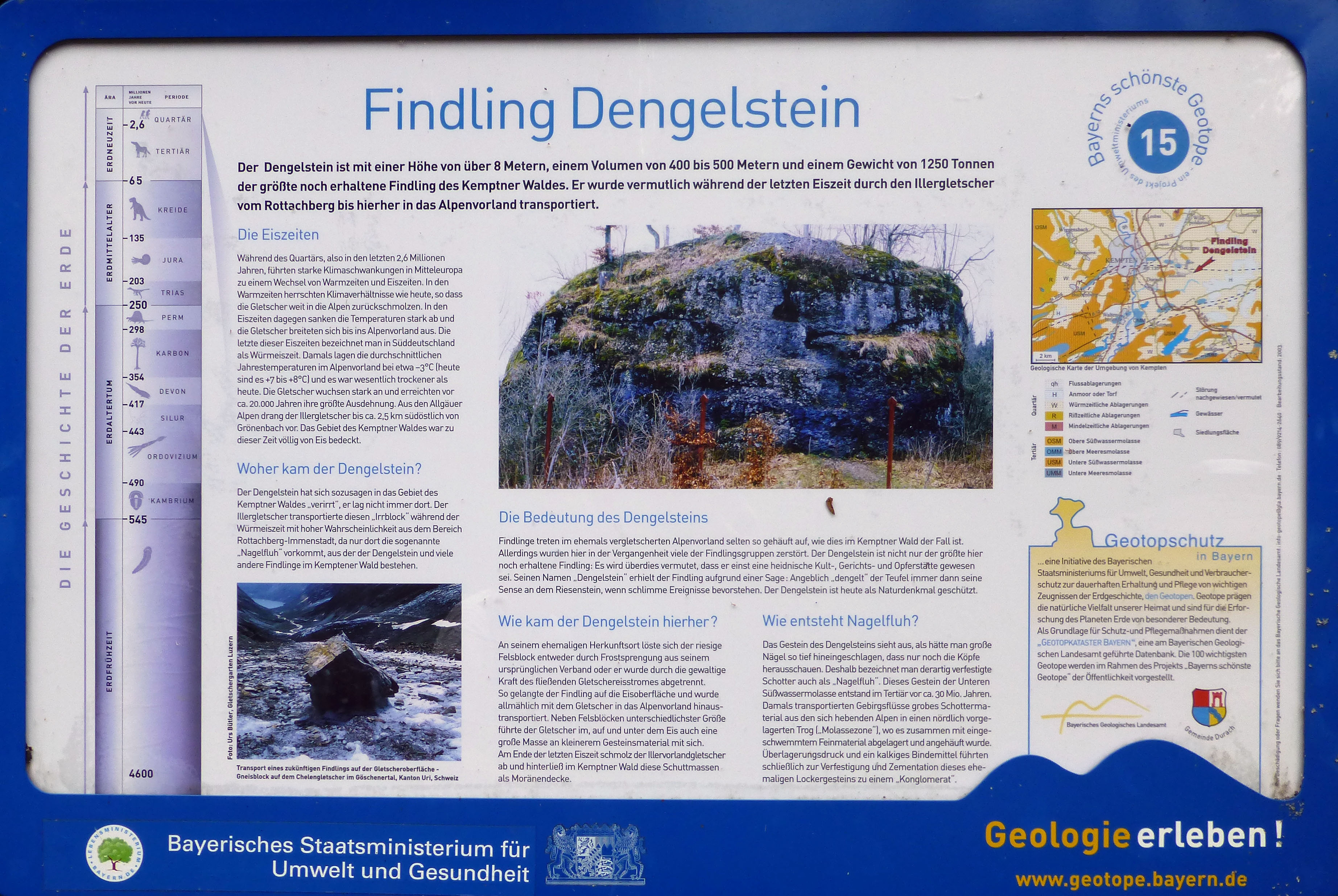
---|---|---|---|---|---|
current | 23:30, 25 July 2014 | 3,690 × 2,472 (1.49 MB) | 1971markus (talk | contribs) | {{Information |Description={{de|Hinweisschild am Geotop Dengelstein, Findling im Kempter Wald}} |Source={{own}} |Date={{Date|2014|07|20}} |Author=© <font face="Comic Sans MS">[[:de:Benutzer:1971markus|1971marku... |
You cannot overwrite this file.
File usage on Commons
The following 3 pages use this file:
Metadata
This file contains additional information such as Exif metadata which may have been added by the digital camera, scanner, or software program used to create or digitize it. If the file has been modified from its original state, some details such as the timestamp may not fully reflect those of the original file. The timestamp is only as accurate as the clock in the camera, and it may be completely wrong.
Camera manufacturer | Panasonic |
---|---|
Camera model | DMC-TZ31 |
Exposure time | 1/400 sec (0.0025) |
F-number | f/3.7 |
ISO speed rating | 100 |
Date and time of data generation | 11:43, 20 July 2014 |
Lens focal length | 6.1 mm |
Latitude | 47° 42′ 37.79″ N |
Longitude | 10° 24′ 23.2″ E |
Author | © 1971markus |
Width | 4,320 px |
Height | 3,240 px |
Bits per component |
|
Pixel composition | RGB |
Orientation | Normal |
Number of components | 3 |
Horizontal resolution | 180 dpi |
Vertical resolution | 180 dpi |
Software used | Adobe Photoshop CS5 Windows |
File change date and time | 00:01, 26 July 2014 |
Y and C positioning | Co-sited |
Exposure Program | Landscape mode (for landscape photos with the background in focus) |
Exif version | 2.3 |
Date and time of digitizing | 11:43, 20 July 2014 |
Meaning of each component |
|
Image compression mode | 4 |
APEX shutter speed | 8.643856 |
APEX aperture | 3.775051 |
APEX exposure bias | 0 |
Maximum land aperture | 3.7734375 APEX (f/3.7) |
Metering mode | Pattern |
Light source | Unknown |
Flash | Flash did not fire, compulsory flash suppression |
Supported Flashpix version | 1 |
Color space | sRGB |
Sensing method | One-chip color area sensor |
File source | Digital still camera |
Scene type | A directly photographed image |
Custom image processing | Normal process |
Exposure mode | Auto exposure |
White balance | Auto white balance |
Digital zoom ratio | 0 |
Focal length in 35 mm film | 34 mm |
Scene capture type | Standard |
Scene control | None |
Contrast | Normal |
Saturation | Normal |
Sharpness | Normal |
GPS time (atomic clock) | 10:38 |
Receiver status | Measurement in progress |
Measurement mode | 2-dimensional measurement |
Measurement precision | Fair (1.1) |
Geodetic survey data used | WGS-84 |
Name of GPS area | --- |
GPS date | 20 July 2014 |
GPS tag version | 2.3.0.0 |
Unique ID of original document | 14E984F5E9D9D41A9B0361E094942FAD |
Date metadata was last modified | 02:01, 26 July 2014 |