File:Densidades de población en España (1930) de.svg

Size of this PNG preview of this SVG file: 734 × 497 pixels. Other resolutions: 320 × 217 pixels | 640 × 433 pixels | 1,024 × 693 pixels | 1,280 × 867 pixels | 2,560 × 1,733 pixels.
Original file (SVG file, nominally 734 × 497 pixels, file size: 1.24 MB)
Captions
Captions
Add a one-line explanation of what this file represents
| Description |
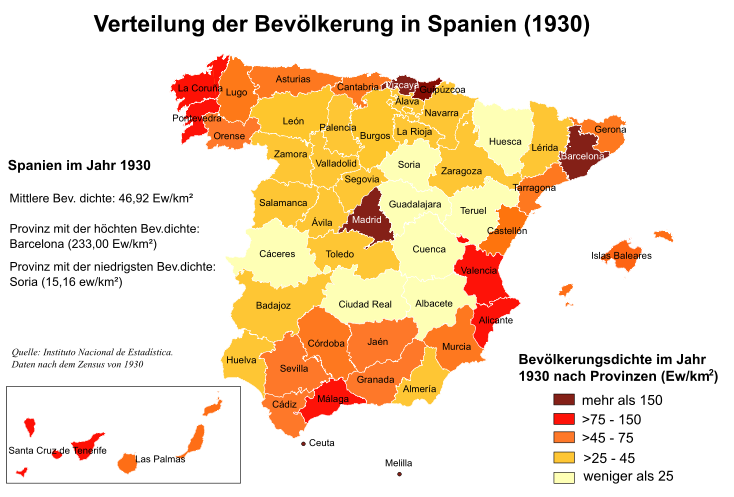
Deutsch: Karte der Bevölkerungsdichte Spaniens nach Provinzen im Jahr 1930, nach Daten des Nationalen Instituts für Statistik
Español: Mapa de España con las densidades de población por provincias, según el censo del Instituto Nacional de Estadística de 1930. |
| Date | (UTC) |
| Source | |
| Author |
|
.svg)
| This is a retouched picture, which means that it has been digitally altered from its original version. Modifications: Deutsche Übersetzung/traducción alemán. The original can be viewed here: Densidades de población en España (1930).svg:
|
| I, the copyright holder of this work, release this work into the public domain. This applies worldwide. In some countries this may not be legally possible; if so: I grant anyone the right to use this work for any purpose, without any conditions, unless such conditions are required by law. |
Original upload log edit
_de.svg&action=edit§ion=1)
This image is a derivative work of the following images:
- File:Densidades_de_población_en_España_(1930).svg licensed with PD-user
- 2007-07-09T01:32:45Z Rodriguillo 568x387 (1566841 Bytes)
- 2007-07-09T01:26:26Z Rodriguillo 571x387 (1566831 Bytes)
- 2007-07-09T01:12:59Z Rodriguillo 571x387 (1567641 Bytes)
- 2007-07-08T14:58:50Z Rodriguillo 569x387 (1691061 Bytes)
- 2007-07-08T14:52:16Z Rodriguillo 569x387 (1690727 Bytes)
- 2007-07-08T14:42:55Z Rodriguillo 788x413 (1693895 Bytes)
- 2007-07-08T14:29:26Z Rodriguillo 778x413 (1660624 Bytes) {{Information |Description= Mapa de [[España]] con las '''densidades de población''' por provincias, según el censo del Instituto Nacional de Estadística de 1930. |Source= Instituto Nacional de Estadística de España [h
File history
Click on a date/time to view the file as it appeared at that time.
| Date/Time | Thumbnail | Dimensions | User | Comment | |
|---|---|---|---|---|---|
| current | 17:04, 10 March 2010 | | 734 × 497 (1.24 MB) | Furfur (talk | contribs) | erneute kosmetische Änderungen (Schriften vereinheitlicht, etc.) |
| 09:33, 9 March 2010 |  | 764 × 504 (1.27 MB) | Furfur (talk | contribs) | kosmetische Änderungen | |
| 09:24, 9 March 2010 |  | 751 × 492 (1.22 MB) | Furfur (talk | contribs) | {{Information |Description={{de|Karte der Bevölkerungsdichte Spaniens nach Provinzen im Jahr 1930, nach Daten des Nationalen Instituts für Statistik}} {{es|Mapa de España con las densidades de población por provincias, según el censo del Institut |
You cannot overwrite this file.
File usage on Commons
There are no pages that use this file.
File usage on other wikis
The following other wikis use this file:
- Usage on de.wikipedia.org
_de.svg&oldid=601299166)