File:Despotate of Morea 1450 es.svg

Size of this PNG preview of this SVG file: 643 × 599 pixels. Other resolutions: 258 × 240 pixels | 515 × 480 pixels | 824 × 768 pixels | 1,099 × 1,024 pixels | 2,198 × 2,048 pixels | 1,303 × 1,214 pixels.
Original file (SVG file, nominally 1,303 × 1,214 pixels, file size: 245 KB)
Captions
Captions
Add a one-line explanation of what this file represents
Summary edit
| Description |
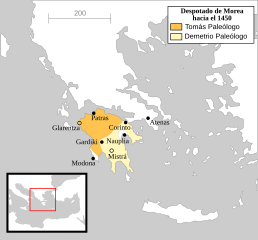
Español: El Despotado de Morea en el año 1450. |
| Date | (UTC) |
| Source |
This file was derived from: Despotate of Morea 1450.svg: |
| Author |
|
| This is a retouched picture, which means that it has been digitally altered from its original version. Modifications: translated into Spanish and text turned into real text (editable). The original can be viewed here: Despotate of Morea 1450.svg:
|
Licensing edit
This file is licensed under the Creative Commons Attribution-Share Alike 3.0 Unported license.
- You are free:
- to share – to copy, distribute and transmit the work
- to remix – to adapt the work
- Under the following conditions:
- attribution – You must give appropriate credit, provide a link to the license, and indicate if changes were made. You may do so in any reasonable manner, but not in any way that suggests the licensor endorses you or your use.
- share alike – If you remix, transform, or build upon the material, you must distribute your contributions under the same or compatible license as the original.
Original upload log edit
This image is a derivative work of the following images:
- File:Despotate_of_Morea_1450.svg licensed with Cc-by-sa-2.5, Cc-by-sa-3.0-migrated, GFDL
- 2011-06-27T10:03:07Z Cplakidas 1303x1214 (212774 Bytes) improved version, showing major towns as well as the division of the Despotate between the brothers Tomas and Demetrios after 1450
- 2007-09-17T02:04:33Z MapMaster 1303x1214 (134119 Bytes) border changes based on discussion with Alekkas (see [[Image talk:Eastern Mediterranean 1450 .svg]])
- 2007-04-14T13:31:21Z MapMaster 1303x1214 (136490 Bytes) Better colour
- 2007-04-14T05:30:53Z MapMaster 1303x1214 (136726 Bytes) A "locator" (text- and language-free) map of the Despotate of Morea in the year 1450. [[Category:Maps of the history of Greece]]
Uploaded with derivativeFX
File history
Click on a date/time to view the file as it appeared at that time.
| Date/Time | Thumbnail | Dimensions | User | Comment | |
|---|---|---|---|---|---|
| current | 17:16, 6 August 2020 | | 1,303 × 1,214 (245 KB) | Rowanwindwhistler (talk | contribs) | Simple colours |
| 17:12, 6 August 2020 |  | 1,303 × 1,214 (245 KB) | Rowanwindwhistler (talk | contribs) | Fake text added. Other minor changes | |
| 11:19, 5 June 2016 |  | 1,303 × 1,214 (155 KB) | Rowanwindwhistler (talk | contribs) | https://en.wikipedia.org/wiki/Wikipedia:WikiProject_Maps/Conventions | |
| 08:12, 19 August 2012 |  | 1,303 × 1,214 (113 KB) | Rowanwindwhistler (talk | contribs) | == {{int:filedesc}} == {{Information |Description={{es|1=El Despotado de Morea en el año 1450.}} |Source={{Derived from|Despotate_of_Morea_1450.svg|display=50}} |Date=2012-08-19 08:11 (UTC) |Author=*File:Despotate_of_Morea_1450.svg: [[User:MapMa... |
You cannot overwrite this file.
File usage on Commons
The following 5 pages use this file:
File usage on other wikis
The following other wikis use this file:
- Usage on ast.wikipedia.org
- Usage on es.wikipedia.org
- Usage on gl.wikipedia.org
- Usage on www.wikidata.org