File:Detailed map of Medicine Lodge, Kansas.png
No higher resolution available.
Detailed_map_of_Medicine_Lodge,_Kansas.png (575 × 425 pixels, file size: 28 KB, MIME type: image/png)
Captions
Captions
Add a one-line explanation of what this file represents
| Description |
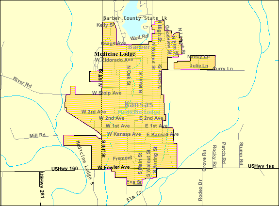
English: Detailed map of Medicine Lodge, Kansas |
|||
| Date | Unknown date; downloaded 21 October 2010 | |||
| Source | http://factfinder.census.gov/servlet/MapItDrawServlet?geo_id=16000US2045500&_bucket_id=50&tree_id=420&context=saff&_lang=en&_sse=on, from http://factfinder.census.gov | |||
| Author | United States Census Bureau | |||
| Permission (Reusing this file) |
|

Original upload log edit
| Date/Time | Dimensions | User | Comment |
|---|---|---|---|
| 21 October 2010, 06:02:30 | 575 × 425 (30787 bytes) | Sbmeirow (talk · contribs) | {{Information |Description={{en|1=Detailed map of {{w|Medicine Lodge, Kansas}}}} |Source=http://factfinder.census.gov/servlet/MapItDrawServlet?geo_id=16000US2045500&_bucket_id=50&tree_id=420&context=saff&_lang=en&_sse=on, from http://factfinder.census.gov |
File history
Click on a date/time to view the file as it appeared at that time.
| Date/Time | Thumbnail | Dimensions | User | Comment | |
|---|---|---|---|---|---|
| current | 06:26, 11 December 2014 | | 575 × 425 (28 KB) | GifTagger (talk | contribs) | Bot: Converting file to superior PNG file. (Source: Detailed_map_of_Medicine_Lodge,_Kansas.gif). This GIF was problematic due to non-greyscale color table. |
You cannot overwrite this file.
File usage on Commons
The following page uses this file:
- File:Detailed map of Medicine Lodge, Kansas.gif (file redirect)
File usage on other wikis
The following other wikis use this file:
- Usage on en.wikipedia.org
- Usage on fa.wikipedia.org
- Usage on fr.wikipedia.org
- Usage on sh.wikipedia.org