File:Detroit Region Footprint.png

Size of this preview: 527 × 600 pixels. Other resolutions: 211 × 240 pixels | 422 × 480 pixels | 675 × 768 pixels | 899 × 1,024 pixels | 1,799 × 2,048 pixels | 9,192 × 10,464 pixels.
Original file (9,192 × 10,464 pixels, file size: 5.39 MB, MIME type: image/png)
Captions
Captions
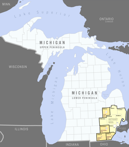
Metropolitan and micropolitan area components of the overall Detroit Combined Statistical Area.
Summary edit
| Description |
English: The Detroit region CSA (as defined the the US Office of Management & Budget) is indicated in both yellow and orange counties in Michigan's Lower Peninsula. The boundaries separating the component metro areas are represented in bold, black lines. The primary cities that each of the metro areas are named for are shown with their footprints as located within each of their metros. |
| Date | |
| Source | Own work |
| Author | Lrgjr72 |
Licensing edit
I, the copyright holder of this work, hereby publish it under the following license:
This file is licensed under the Creative Commons Attribution-Share Alike 4.0 International license.
- You are free:
- to share – to copy, distribute and transmit the work
- to remix – to adapt the work
- Under the following conditions:
- attribution – You must give appropriate credit, provide a link to the license, and indicate if changes were made. You may do so in any reasonable manner, but not in any way that suggests the licensor endorses you or your use.
- share alike – If you remix, transform, or build upon the material, you must distribute your contributions under the same or compatible license as the original.
File history
Click on a date/time to view the file as it appeared at that time.
| Date/Time | Thumbnail | Dimensions | User | Comment | |
|---|---|---|---|---|---|
| current | 05:52, 29 December 2022 | | 9,192 × 10,464 (5.39 MB) | Lrgjr72 (talk | contribs) | Uploaded own work with UploadWizard |
You cannot overwrite this file.
File usage on Commons
There are no pages that use this file.
File usage on other wikis
The following other wikis use this file:
- Usage on en.wikipedia.org