File:Deutzer Friedhof – 360°-Panorama aus der Luft.jpg

Size of this preview: 800 × 400 pixels. Other resolutions: 320 × 160 pixels | 640 × 320 pixels | 1,024 × 512 pixels | 1,280 × 640 pixels | 2,560 × 1,280 pixels | 8,192 × 4,096 pixels.
Original file (8,192 × 4,096 pixels, file size: 13.72 MB, MIME type: image/jpeg)
Captions
Captions
Add a one-line explanation of what this file represents
Summary edit
| Description |
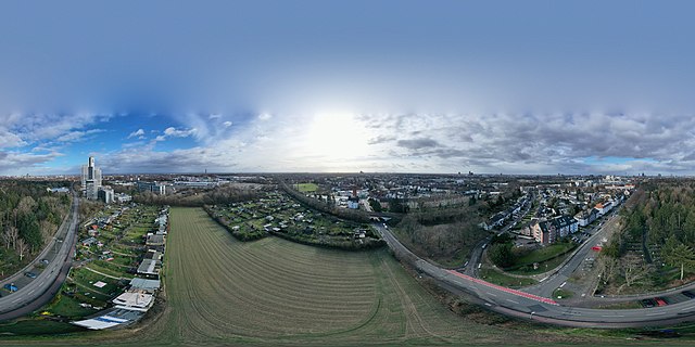
Deutsch: Der Friedhof des Kölner Stadtteils Deutz, als 360°-Panorama aus der Luft fotografiert. Im Süden ist eine Bahntrasse zu sehen, zwei Schrebergartenanlagen, unmittelbar dahinter in rotem Backstein die Kirche Hl. Dreifaltigkeit. Im Osten das Hochhaus des TÜV Rheinland, südlich davon das Übungsgelände für angehende Führerscheinbesitzer. Weit im Hintgrund deutet sich das Siebengebirge an. Nur wenige Gräber des Friedhofs (Nordrichtung) sind wegen der starken Bewaldung zu sehen. Der Rolshofer Kirchweg führt nach Nordwesten Richtung Köln Zentrum, wo im Hintergrund der Dom zu sehen ist. |
| Date | |
| Source | Own work |
| Author | Maximilian Schönherr |
| 360° | View in 360° panoramic viewer
|
|---|
| Camera location | | View this and other nearby images on: OpenStreetMap |
|---|
Licensing edit
I, the copyright holder of this work, hereby publish it under the following license:
This file is licensed under the Creative Commons Attribution-Share Alike 4.0 International license.
- You are free:
- to share – to copy, distribute and transmit the work
- to remix – to adapt the work
- Under the following conditions:
- attribution – You must give appropriate credit, provide a link to the license, and indicate if changes were made. You may do so in any reasonable manner, but not in any way that suggests the licensor endorses you or your use.
- share alike – If you remix, transform, or build upon the material, you must distribute your contributions under the same or compatible license as the original.
File history
Click on a date/time to view the file as it appeared at that time.
| Date/Time | Thumbnail | Dimensions | User | Comment | |
|---|---|---|---|---|---|
| current | 16:22, 9 February 2019 | | 8,192 × 4,096 (13.72 MB) | Maximilian Schönherr (talk | contribs) | User created page with UploadWizard |
You cannot overwrite this file.
File usage on Commons
The following 2 pages use this file:
File usage on other wikis
The following other wikis use this file:
- Usage on de.wikipedia.org
- Usage on www.wikidata.org