File:Dewar's Lane Granary from Sallyport - geograph.org.uk - 1209878.jpg
No higher resolution available.
Dewar's_Lane_Granary_from_Sallyport_-_geograph.org.uk_-_1209878.jpg (640 × 480 pixels, file size: 78 KB, MIME type: image/jpeg)
Captions
Captions
Add a one-line explanation of what this file represents
Summary edit
| Description |
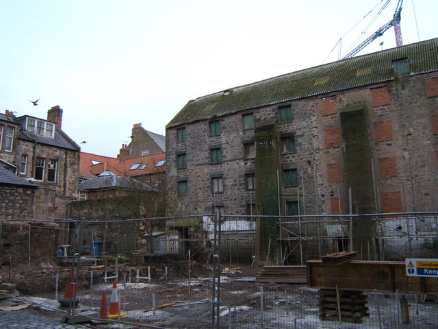
English: Dewar's Lane Granary from Sallyport Berwick (= 'barley town') originally had eight granaries - Dewar's Lane Granary is the only surviving one, and it is being redeveloped into a Youth Hostel and bistro. This view is from Sallyport, an old lane which passes under the Town Walls via a narrow tunnel to the riverside. |
| Date | |
| Source | From geograph.org.uk |
| Author | Barbara Carr |
| Attribution (required by the license) | Barbara Carr / Dewar's Lane Granary from Sallyport / |
| Camera location | | View this and other nearby images on: OpenStreetMap |
|---|
_heading:112.00&language=en)
| Object location | | View this and other nearby images on: OpenStreetMap |
|---|
_heading:112.00&language=en)
Licensing edit

|
This image was taken from the Geograph project collection. See this photograph's page on the Geograph website for the photographer's contact details. The copyright on this image is owned by Barbara Carr and is licensed for reuse under the Creative Commons Attribution-ShareAlike 2.0 license.
|
This file is licensed under the Creative Commons Attribution-Share Alike 2.0 Generic license.
Attribution: Barbara Carr
- You are free:
- to share – to copy, distribute and transmit the work
- to remix – to adapt the work
- Under the following conditions:
- attribution – You must give appropriate credit, provide a link to the license, and indicate if changes were made. You may do so in any reasonable manner, but not in any way that suggests the licensor endorses you or your use.
- share alike – If you remix, transform, or build upon the material, you must distribute your contributions under the same or compatible license as the original.
File history
Click on a date/time to view the file as it appeared at that time.
| Date/Time | Thumbnail | Dimensions | User | Comment | |
|---|---|---|---|---|---|
| current | 03:11, 26 February 2011 | | 640 × 480 (78 KB) | GeographBot (talk | contribs) | == {{int:filedesc}} == {{Information |description={{en|1=Dewar's Lane Granary from Sallyport Berwick (= 'barley town') originally had eight granaries - Dewar's Lane Granary is the only surviving one, and it is being redeveloped into a Youth Hostel and bis |
You cannot overwrite this file.
File usage on Commons
There are no pages that use this file.
File usage on other wikis
The following other wikis use this file:
- Usage on en.wikipedia.org
- Usage on www.wikidata.org