File:Districts of Punjab, Pakistan.png

Size of this preview: 582 × 600 pixels. Other resolutions: 233 × 240 pixels | 466 × 480 pixels | 745 × 768 pixels | 993 × 1,024 pixels | 1,987 × 2,048 pixels | 3,880 × 4,000 pixels.
Original file (3,880 × 4,000 pixels, file size: 2.64 MB, MIME type: image/png)
Captions
Captions
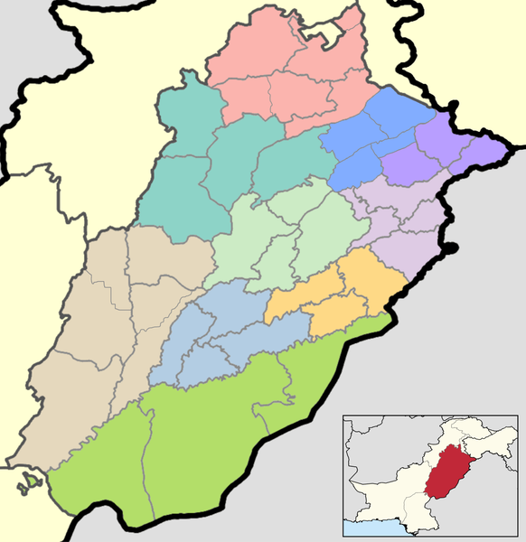
A map showing the Districts of Punjab, Pakistan.
Summary
edit
| Description |
English: This is a map showing each and every district of Punjab. The map is accurate as of September 30, 2020 and has been made using data from the Pakistan Bureau of Statistics and UN OCHA's HumData Database (which citypopulation.de uses). Each color depicts a different administrative division (higher than a district but lower than a province).
A category full of these maps listed nicely can be found here. |
| Date | |
| Source | Own work |
| Author | User:Abbasi786786 |
Licensing
edit
I, the copyright holder of this work, hereby publish it under the following license:
This file is licensed under the Creative Commons Attribution-Share Alike 4.0 International license.
- You are free:
- to share – to copy, distribute and transmit the work
- to remix – to adapt the work
- Under the following conditions:
- attribution – You must give appropriate credit, provide a link to the license, and indicate if changes were made. You may do so in any reasonable manner, but not in any way that suggests the licensor endorses you or your use.
- share alike – If you remix, transform, or build upon the material, you must distribute your contributions under the same or compatible license as the original.
File history
Click on a date/time to view the file as it appeared at that time.
| Date/Time | Thumbnail | Dimensions | User | Comment | |
|---|---|---|---|---|---|
| current | 21:39, 5 December 2022 | | 3,880 × 4,000 (2.64 MB) | Saad Ali Khan Pakistan (talk | contribs) | added Gujrat division and new district boundaries |
| 19:06, 23 August 2020 |  | 3,880 × 4,000 (2.22 MB) | Abbasi786786 (talk | contribs) | Adjusted map | |
| 23:06, 16 August 2020 |  | 3,880 × 4,000 (2.3 MB) | Abbasi786786 (talk | contribs) | Improved Map | |
| 19:49, 14 May 2020 |  | 1,400 × 1,385 (450 KB) | Abbasi786786 (talk | contribs) | Cropped | |
| 23:00, 13 May 2020 |  | 2,720 × 1,890 (661 KB) | Abbasi786786 (talk | contribs) | Uploaded own work with UploadWizard |
You cannot overwrite this file.
File usage on Commons
There are no pages that use this file.
File usage on other wikis
The following other wikis use this file:
- Usage on en.wikipedia.org
- Punjab, Pakistan
- User talk:Aalahazrat~enwiki
- Jhelum District
- Rawalpindi District
- Lahore District
- Muzaffargarh District
- Toba Tek Singh District
- Bahawalpur District
- Jhang District
- Khushab District
- Chakwal District
- Layyah District
- Bahawalnagar District
- Okara District
- Sahiwal District
- Vehari District
- Attock District
- Gujrat District
- Multan District
- Sargodha District
- Dera Ghazi Khan District
- Khanewal District
- Mandi Bahauddin District
- Rahim Yar Khan District
- Sialkot District
- Mianwali District
- Faisalabad District
- Bhakkar District
- Gujranwala District
- Hafizabad District
- Kasur District
- Lodhran District
- Narowal District
- Nankana Sahib District
- Pakpattan District
- Rajanpur District
- Sheikhupura District
- Chiniot District
- List of districts in Punjab, Pakistan
- Template:Districts of Punjab, Pakistan
- Rajan Pur Kalan
- Murree District
- Wazirabad District
- Kot Addu District
- Taunsa District
- Talagang District
- Jampur District
- Usage on ne.wikipedia.org
View more global usage of this file.