File:Djerba topographic map-ar.svg

Size of this PNG preview of this SVG file: 666 × 599 pixels. Other resolutions: 267 × 240 pixels | 533 × 480 pixels | 853 × 768 pixels | 1,138 × 1,024 pixels | 2,276 × 2,048 pixels | 1,100 × 990 pixels.
Original file (SVG file, nominally 1,100 × 990 pixels, file size: 570 KB)
Captions
Captions
Add a one-line explanation of what this file represents
Summary edit
| Camera location | | View this and other nearby images on: OpenStreetMap |
|---|
| Description |
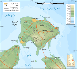
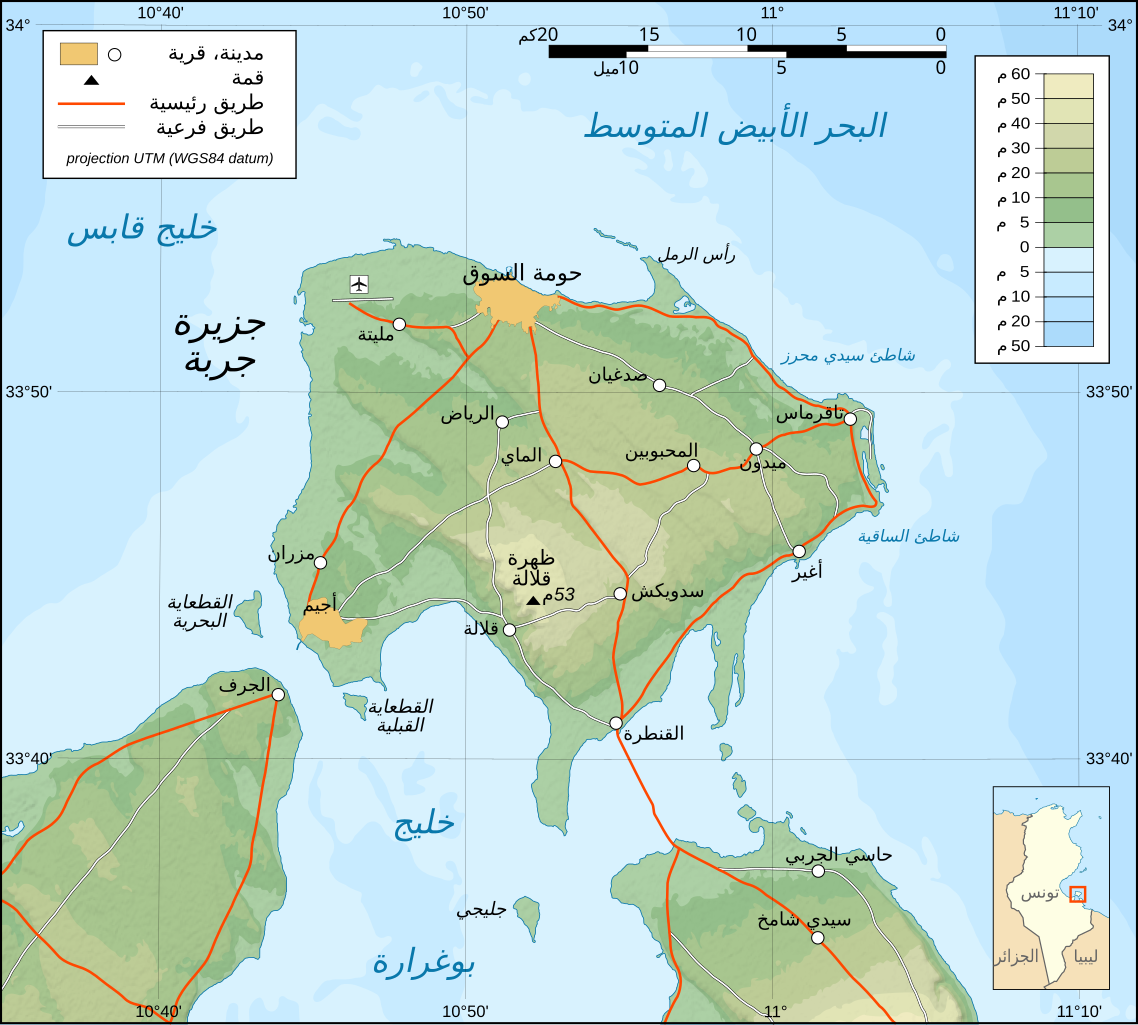
العربية: خارطة جربة بتونس باللغة العربية.
English: Topographic map in Arabic of Djerba in Tunisia.
Deutsch: Topografische Karte von Djerba in Tunesien in arabische Sprache
Français : Carte topographique en arabe de l'île de Djerba, Tunisie
Norsk bokmål: Topografisk kart over Djerba i Tunisia, på arabsk. |
| Date | |
| Source |
Image:Djerba topographic map-fr.svg This W3C-unspecified vector image was created with Inkscape . |
| Author | Eric Gaba (translated by DrFO.Jr.Tn) |
| Permission (Reusing this file) |
GFDL & CC-by-SA |
| Other versions |
[]
|


|
This SVG file contains embedded text that can be translated into your language, using any capable SVG editor, text editor or the SVG Translate tool. For more information see: About translating SVG files. |
Licensing edit
This file is licensed under the Creative Commons Attribution-Share Alike 3.0 Unported license.
- You are free:
- to share – to copy, distribute and transmit the work
- to remix – to adapt the work
- Under the following conditions:
- attribution – You must give appropriate credit, provide a link to the license, and indicate if changes were made. You may do so in any reasonable manner, but not in any way that suggests the licensor endorses you or your use.
- share alike – If you remix, transform, or build upon the material, you must distribute your contributions under the same or compatible license as the original.
File history
Click on a date/time to view the file as it appeared at that time.
| Date/Time | Thumbnail | Dimensions | User | Comment | |
|---|---|---|---|---|---|
| current | 15:16, 3 September 2008 | | 1,100 × 990 (570 KB) | Sting (talk | contribs) | New standard colors |
| 10:49, 1 April 2008 |  | 1,100 × 990 (577 KB) | DrFO.Jr.Tn (talk | contribs) | ||
| 10:45, 1 April 2008 |  | 1,100 × 990 (576 KB) | DrFO.Jr.Tn (talk | contribs) | ||
| 10:34, 1 April 2008 |  | 1,100 × 990 (576 KB) | DrFO.Jr.Tn (talk | contribs) | ||
| 10:30, 1 April 2008 |  | 1,100 × 990 (576 KB) | DrFO.Jr.Tn (talk | contribs) | ||
| 10:25, 1 April 2008 |  | 1,100 × 990 (576 KB) | DrFO.Jr.Tn (talk | contribs) | ||
| 10:16, 1 April 2008 |  | 1,100 × 990 (576 KB) | DrFO.Jr.Tn (talk | contribs) | ||
| 09:58, 1 April 2008 |  | 1,100 × 990 (577 KB) | DrFO.Jr.Tn (talk | contribs) | == Description == {{Location|33|45|00|N|10|55|00|E|scale:500000}} {{Information |Description= {{ar|خارطة جربة بتونس باللغة العربية.}} {{en|Topographic map in Arabic of Djerba in Tunisia.} |
You cannot overwrite this file.
File usage on Commons
The following 7 pages use this file:
File usage on other wikis
The following other wikis use this file:
- Usage on ar.wikipedia.org
- Usage on ur.wikipedia.org