File:Doe Lea geograph-3562060-by-Ben-Brooksbank.jpg

Size of this preview: 800 × 449 pixels. Other resolutions: 320 × 180 pixels | 640 × 359 pixels | 1,024 × 575 pixels | 1,280 × 719 pixels | 2,394 × 1,344 pixels.
Original file (2,394 × 1,344 pixels, file size: 2.28 MB, MIME type: image/jpeg)
Captions
Captions
Add a one-line explanation of what this file represents
Summary edit
| Description |
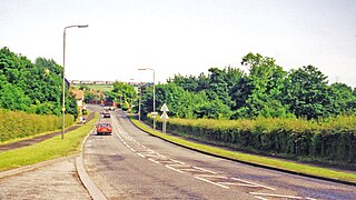
English: On A617 approaching site of Glapwell station, 1998. View eastward at Bramley Vale. Just ahead in the dip the ex-Midland Doe Lea branch, (Chesterfield - Barrow Hill -) Staveley (to left) - (to right) Pleasley - (Mansfield) line, crossed until late 1965. Glapwell station had been on the left and was closed long ago, 28/7/30. |
| Date | |
| Source | From geograph.org.uk |
| Author | Ben Brooksbank |
| Permission (Reusing this file) |
Creative Commons Attribution Share-alike license 2.0 |
| Attribution (required by the license) | Ben Brooksbank / On A617 approaching site of Glapwell station, 1998 / |
| Camera location | | View this and other nearby images on: OpenStreetMap |
|---|
Licensing edit

|
This image was taken from the Geograph project collection. See this photograph's page on the Geograph website for the photographer's contact details. The copyright on this image is owned by Ben Brooksbank and is licensed for reuse under the Creative Commons Attribution-ShareAlike 2.0 license.
|
This file is licensed under the Creative Commons Attribution-Share Alike 2.0 Generic license.
Attribution: Ben Brooksbank
- You are free:
- to share – to copy, distribute and transmit the work
- to remix – to adapt the work
- Under the following conditions:
- attribution – You must give appropriate credit, provide a link to the license, and indicate if changes were made. You may do so in any reasonable manner, but not in any way that suggests the licensor endorses you or your use.
- share alike – If you remix, transform, or build upon the material, you must distribute your contributions under the same or compatible license as the original.
File history
Click on a date/time to view the file as it appeared at that time.
| Date/Time | Thumbnail | Dimensions | User | Comment | |
|---|---|---|---|---|---|
| current | 07:31, 10 August 2013 | | 2,394 × 1,344 (2.28 MB) | Chevin (talk | contribs) | == {{int:filedesc}} == {{Information |Description={{en|1='''On A617 approaching site of Glapwell station, 1998.'''<br/> View eastward at Bramley Vale. Just ahead in the dip the ex-Midland Doe Lea branch, (Chesterfield - Barrow Hill -) Staveley (to left... |
You cannot overwrite this file.
File usage on Commons
There are no pages that use this file.