File:Double Page Plate No. 1, Part of Ward 24, Section 9. (Bounded by Harlem River, Old Croton Aqueduct, Nelson Avenue, E. 170th St., and High Bridge.) NYPL1533054.tiff

Size of this JPG preview of this TIF file: 799 × 600 pixels. Other resolutions: 320 × 240 pixels | 640 × 480 pixels | 1,023 × 768 pixels | 1,280 × 961 pixels | 2,560 × 1,922 pixels | 7,230 × 5,428 pixels.
Original file (7,230 × 5,428 pixels, file size: 112.28 MB, MIME type: image/tiff)
Captions
Captions
Add a one-line explanation of what this file represents
Summary edit
| Description | Double Page Plate No. 1, Part of Ward 24, Section 9. [Bounded by Harlem River, Old Croton Aqueduct, Nelson Avenue, E. 170th St., and High Bridge.]; Atlases of New York city. / Atlas of the borough of the Bronx, city of New York : based upon official plans and maps on file in the various city offices; supplemented by careful field measurements and personal observations, by and under the supervision of Hugo Ullitz. | |||||||||||||||||||||||
| Catalogue call number | Map Div.+++ (Bronx, New York) (Hyde, E. B., Map Co., Inc. Atlas of the borough of the Bronx, city of New York. 1900) | |||||||||||||||||||||||
| Item/Page/Plate | 1 | |||||||||||||||||||||||
| Date | ||||||||||||||||||||||||
| Source |
http://digitalgallery.nypl.org/nypldigital/dgkeysearchdetail.cfm?imageID=1533054
|
|||||||||||||||||||||||
| Author | E. Belcher Hyde Map Company -- Publisher | |||||||||||||||||||||||
| Permission (Reusing this file) |
From The Lionel Pincus and Princess Firyal Map Division. http://maps.nypl.org
|
|||||||||||||||||||||||
| Source description | 4 v. [in 5?] : chiefly col. maps ; 69 cm. | |||||||||||||||||||||||
| Location | Stephen A. Schwarzman Building / The Lionel Pincus and Princess Firyal Map Division | |||||||||||||||||||||||
| Digital item published | 8-24-2006; updated 3-25-2011 | |||||||||||||||||||||||
| Digital ID | 1533054 | |||||||||||||||||||||||

The making of this file was supported by Wikimedia UK.
To see other files made with the support of Wikimedia UK, please see the category Supported by Wikimedia UK.
|
File history
Click on a date/time to view the file as it appeared at that time.
| Date/Time | Thumbnail | Dimensions | User | Comment | |
|---|---|---|---|---|---|
| current | 13:46, 28 February 2021 |  | 7,230 × 5,428 (112.28 MB) | Tm (talk | contribs) | Reverted to version as of 20:06, 27 April 2014 (UTC) |
| 06:23, 27 February 2021 | 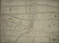 | 6,638 × 4,895 (92.96 MB) | Featous (talk | contribs) | Cropped 8 % horizontally, 10 % vertically using CropTool with lossless mode. | |
| 20:06, 27 April 2014 | 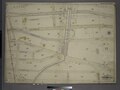 | 7,230 × 5,428 (112.28 MB) | Fæ (talk | contribs) | GWToolset:: Creating mediafile for Fæ. Tranche 3 5495-7474 (2) |
You cannot overwrite this file.
File usage on Commons
There are no pages that use this file.