File:Down Northeastern Ramp into 'Hidden Valley' on Mars Pia18599 0.jpg

Original file (1,024 × 1,024 pixels, file size: 527 KB, MIME type: image/jpeg)
Captions
Captions
Summary edit
| DescriptionDown Northeastern Ramp into 'Hidden Valley' on Mars Pia18599 0.jpg |
English: Down Northeastern Ramp into 'Hidden Valley' on Mars
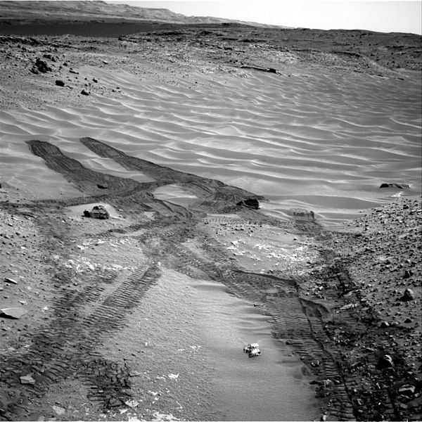
This image from NASA's Curiosity Mars rover looks down the ramp at the northeastern end of "Hidden Valley" and across the sandy-floored valley to lower slopes of Mount Sharp on the horizon. Curiosity used its Navigation Camera (Navcam) to capture this southward view during the 717th Martian day, or sol, of the rover's work on Mars (Aug. 12, 2014). By that date, Curiosity had entered and exited the valley via this ramp. The rover subsequently descended the ramp partway to approach a pale outcrop bearing a candidate rock for drilling. The drilling candidate, called "Bonanza King," is just outside of this view, closer to the rover than the foreground of the scene. For scale, the distance between parallel pairs of Curiosity's wheel tracks is about 9 feet (2.7 meters). A map showing Hidden Valley is at http://photojournal.jpl.nasa.gov/catalog/PIA18408 . NASA's Jet Propulsion Laboratory, a division of the California Institute of Technology, Pasadena, manages the Mars Science Laboratory Project for NASA's Science Mission Directorate, Washington. JPL designed and built the project's Curiosity rover and the rover's Navcam. Credit: NASA/JPL-CaltechPolski: W Dół Rampą Na Północny Wschód do Doliny 'Hidden Valley' na Marsie
Zdjęcie to przedstawia widok z należącego do NASA łazika Curiosity patrzącego w dół rampy schodzącej w kierunku północnego-wschodniego zakończenia doliny "Hidden Valley" stanowiącej piaszczyste przejście do dolnych stoków Mount Sharp widniejących na horyzoncie. Curiosity użył swojej nawigacyjnej kamery (Navcam) do uchwyceniania widoku skierowanego na południe w 717 marsjańskim dniu pracy łazika na Marsie (12 sierpnia 2014). W tym dniu Curiosity korzystając z rampy wszedł i wyszedł z doliny. Łazik następnie zjechał nieco w dół aby zbliżyć się do jasnej odkrywki zawierającej skałę będącą kandydatem do kolejnego wiercenia. Kandydat do wiercenia, zwany "Bonanza King" jest po prostu poza tym widokiem, bliżej łazika niż pierwszy plan tej sceny. Dla porównania, odległość pomiedzy równoległymi śladami pozostawionymi przez koła łazika Curiosity wynosi około 2.7 metra. Mapa przedstawiająca dolinę Hidden Valley znajduje się na stronie http://photojournal.jpl.nasa.gov/catalog/PIA18408 . Należące do NASA Jet Propulsion Laboratory, będące oddziałem instytutu California Institute of Technology, kieruje łazikiem Mars Science Laboratory Project i orbiterem Mars Reconnaissance Orbiter Project dla należącego do NASA dyrektoriatu Science Mission Directorate, z Waszyntonu. JPL zaprojektował i zbudował łazik Curiosity oraz kamery Navcam. Credit: NASA/JPL-Caltech |
| Date | |
| Source | http://www.nasa.gov/jpl/msl/pia18599/#.U_vJ7KOnc9C |
| Author | NASA |
Licensing edit
| Public domainPublic domainfalsefalse |
| This file is in the public domain in the United States because it was solely created by NASA. NASA copyright policy states that "NASA material is not protected by copyright unless noted". (See Template:PD-USGov, NASA copyright policy page or JPL Image Use Policy.) |  | |
 |
Warnings:
|
File history
Click on a date/time to view the file as it appeared at that time.
| Date/Time | Thumbnail | Dimensions | User | Comment | |
|---|---|---|---|---|---|
| current | 23:46, 25 August 2014 |  | 1,024 × 1,024 (527 KB) | Romkur (talk | contribs) | {{Information |Description={{en|1= Down Northeastern Ramp into 'Hidden Valley' on Mars This image from NASA's Curiosity Mars rover looks down the ramp at the northeastern end of "Hidden Valley" and across the sandy-floored valley to lower slopes of Mo... |
You cannot overwrite this file.
File usage on Commons
There are no pages that use this file.
File usage on other wikis
The following other wikis use this file:
- Usage on pl.wikipedia.org