File:Downward to Dishon River.JPG

Size of this preview: 800 × 533 pixels. Other resolutions: 320 × 213 pixels | 640 × 427 pixels | 1,024 × 683 pixels | 1,280 × 853 pixels | 2,560 × 1,707 pixels | 4,608 × 3,072 pixels.
Original file (4,608 × 3,072 pixels, file size: 8.36 MB, MIME type: image/jpeg)
Captions
Captions
Add a one-line explanation of what this file represents
Summary
edit| Description |
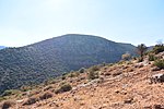
Deutsch: Der Israel National Trail geht steil abwärts zum Grund des ausgetrocknetem Dishon Rivers.
English: The Israel National Trail ist going down steep descent to dry Dishon River. |
| Date | |
| Source | Own work |
| Author | Jotpe |
| Place[1] | Deutsch: Israel National Trail, Mevoot HaHermon Regional Council, Nordbezirk, Israel English: Israel National Trail, Mevoot HaHermon Regional Council, North District, Israel עברית: Israel National Trail, מועצה אזורית מבואות החרמון, מחוז הצפון, ישראל |
| Image Number | 186 |
| Height | 313 |
| Camera location | | View this and other nearby images on: OpenStreetMap |
|---|
Navigation for Fotoproject Israel National Trail 2014
editnext
-
 Alma Heights.JPG
 -
 Downward to Dishon River.JPG
 -
 Dry Dishon River.JPG
 -
 Dry Dishon River 2.JPG
 -
 Dry Dishon River 3.JPG
 -
 Lookout above the Dishon River.JPG


The production, editing or release of this file was supported by the Community-Budget of Wikimedia Deutschland. To see other files made with the support of Wikimedia Deutschland, please see the category Supported by Wikimedia Deutschland. |
Licensing
edit
I, the copyright holder of this work, hereby publish it under the following license:
This file is licensed under the Creative Commons Attribution-Share Alike 4.0 International license.
- You are free:
- to share – to copy, distribute and transmit the work
- to remix – to adapt the work
- Under the following conditions:
- attribution – You must give appropriate credit, provide a link to the license, and indicate if changes were made. You may do so in any reasonable manner, but not in any way that suggests the licensor endorses you or your use.
- share alike – If you remix, transform, or build upon the material, you must distribute your contributions under the same or compatible license as the original.
Notes for Share Alike in Openstreetmap
editDeutsch: Informationen aus diesem Dokument/Foto können expliziet für Openstreetmap verwendet werden. Als Share-Alike reicht mir User jotpe @ Wikimedia Commons: Downward to Dishon River.JPG in der Source-Angabe beim Upload der OSM-Daten.
English: Information in this document / photo can be expliziet used for OpenStreetMap. Share-Alike is fullfilled by User jotpe @ Wikimedia Commons: Downward to Dishon River.JPG in the source field specified on upload of OSM data.
Sources
edit
File history
Click on a date/time to view the file as it appeared at that time.
| Date/Time | Thumbnail | Dimensions | User | Comment | |
|---|---|---|---|---|---|
| current | 07:03, 5 December 2015 | | 4,608 × 3,072 (8.36 MB) | Jotpe (talk | contribs) |
You cannot overwrite this file.
File usage on Commons
The following 9 pages use this file:
- User:Geagea/Israel/2015 December 5
- User:Nicolas Rück (WMDE)/Supported by Wikimedia Deutschland 2015/3
- File:Alma Heights.JPG
- File:Dishon Stream Nature Reserve sign.JPG
- File:Downward to Dishon River.JPG
- File:Dry Dishon River.JPG
- File:Dry Dishon River 2.JPG
- File:Lookout above the Dishon River.JPG
- File:Rusty gate.JPG