File:Droß - Kirche.JPG

Size of this preview: 800 × 503 pixels. Other resolutions: 320 × 201 pixels | 640 × 403 pixels | 1,024 × 644 pixels | 1,280 × 806 pixels | 2,560 × 1,611 pixels | 4,441 × 2,795 pixels.
Original file (4,441 × 2,795 pixels, file size: 9.91 MB, MIME type: image/jpeg)
Captions
Captions
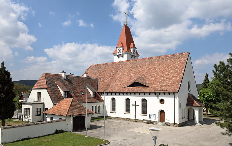
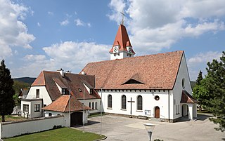
Parish church in Droß, Lower Austria
Summary edit
| Description |
Deutsch: Südostansicht der röm.-kath. Pfarr- und Wallfahrtskirche Maria Fatima und des angebauten Pfarrhofes in der niederösterreichischen Gemeinde Droß.
Die Kirche mit einem seitlich gestellten Turm und Satteldach wurde im Heimatstil errichtet. Sie wurde ab 1949 nach Plänen des Architekten Helmut Schopper aus Langenlois erbaut und am 3. Mai 1953 vom St. Pöltner Bischof-Koadjutor, dem späteren Wiener Kardinal Dr. Franz König, geweiht. |
| Date | |
| Source | Own work |
| Author | C.Stadler/Bwag |
| Permission (Reusing this file) |
Deutsch: Hallo, du darfst mein Foto kostenlos nutzen, aber nenne mich bitte als Fotograf, beispielsweise „Foto: C.Stadler/Bwag“ oder © C.Stadler/Bwag; CC-BY-SA-4.0. Auf mehr Angaben bestehe ich nicht - im Gegensatz zu manch anderen, die die Vorgaben der unten angeführten Lizenzierung auf Punkt und Beistrich einfordern. English: Feel free to use my photos, but please mention me as the author like © C.Stadler/Bwag or © C.Stadler/Bwag; CC-BY-SA-4.0 (that's good enough) and if you want send me a message: bwag@gmx.net. |
| Object location | | View this and other nearby images on: OpenStreetMap |
|---|
| Camera location | | View this and other nearby images on: OpenStreetMap |
|---|
Licensing edit
I, the copyright holder of this work, hereby publish it under the following license:
This file is licensed under the Creative Commons Attribution-Share Alike 4.0 International license.
- You are free:
- to share – to copy, distribute and transmit the work
- to remix – to adapt the work
- Under the following conditions:
- attribution – You must give appropriate credit, provide a link to the license, and indicate if changes were made. You may do so in any reasonable manner, but not in any way that suggests the licensor endorses you or your use.
- share alike – If you remix, transform, or build upon the material, you must distribute your contributions under the same or compatible license as the original.
File history
Click on a date/time to view the file as it appeared at that time.
| Date/Time | Thumbnail | Dimensions | User | Comment | |
|---|---|---|---|---|---|
| current | 20:25, 5 May 2019 | | 4,441 × 2,795 (9.91 MB) | Bwag (talk | contribs) | {{Information |Description= {{de|1= Südostansicht der röm.-kath. Pfarr- und Wallfahrtskirche Maria Fatima und des angebauten Pfarrhofes in der niederösterreichischen Gemeinde Droß.<br/>Die Kirche mit einem seitlich gestellten Turm und Satteldach wurde im Heimatstil errichtet. Sie wurde ab 1949 nach Plänen des Architekten Helmut Schopper aus Langenlois errichtet und am 3. Mai 1953 vom St. Pöltner Bischof-Koadjutor, dem späteren Wiener Kardinal Dr. [[:de:F... |
You cannot overwrite this file.
File usage on Commons
The following page uses this file:
File usage on other wikis
The following other wikis use this file:
- Usage on de.wikipedia.org
- Usage on en.wikipedia.org
- Usage on et.wikipedia.org
- Usage on nl.wikipedia.org
- Usage on www.wikidata.org