File:Dry Wash Bridge north of flattops. Looking NW. - Petrified Forest National Park Roads and Bridges, Holbrook, Navajo County, AZ HAER AZ-58-22.tif

Original file (5,242 × 4,225 pixels, file size: 21.12 MB, MIME type: image/tiff)
Captions
Captions
Summary edit
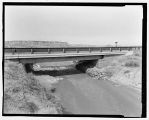
| Dry Wash Bridge north of flattops. Looking NW. - Petrified Forest National Park Roads and Bridges, Holbrook, Navajo County, AZ | ||||
|---|---|---|---|---|
| Photographer |
Grogan, Brian Related names:
|
|||
| Title |
Dry Wash Bridge north of flattops. Looking NW. - Petrified Forest National Park Roads and Bridges, Holbrook, Navajo County, AZ |
|||
| Depicted place | Arizona; Navajo County; Holbrook | |||
| Date | 2001 | |||
| Dimensions | 4 x 5 in. | |||
| Current location |
Library of Congress Prints and Photographs Division Washington, D.C. 20540 USA http://hdl.loc.gov/loc.pnp/pp.print |
|||
| Accession number |
HAER AZ-58-22 |
|||
| Credit line |
|
|||
| Notes |
The design and construction of the roads and bridges at Petrified Forest National Park reflect larger national trends, including the shift from rail tourism to auto travel and the increasing post-World War II reliance on roads for economic gain, including heritage tourism. The history of their construction reflects the application of New Deal work programs to improve the nation's transportation system, as well as the later infusion of federal funding as part of the "Mission 66" initiative. The roads and bridges reflect the prodigious effort by planners to imbue the American driving experience with education opportunities, scenic beauty and recreational relaxation.
|
|||
| Source | https://www.loc.gov/pictures/item/az0476.photos.193700p | |||
| Permission (Reusing this file) |
|
|||

| Object location | | View this and other nearby images on: OpenStreetMap |
|---|
File history
Click on a date/time to view the file as it appeared at that time.
| Date/Time | Thumbnail | Dimensions | User | Comment | |
|---|---|---|---|---|---|
| current | 22:13, 1 July 2014 |  | 5,242 × 4,225 (21.12 MB) | Fæ (talk | contribs) | GWToolset: Creating mediafile for Fæ. HABS 1 July 2014 (201:300) |
You cannot overwrite this file.
File usage on Commons
The following page uses this file: