File:EAST SIDE, SHOWING OCTAGONAL CROSS-HALL - Hugh C. Leckey House, State Highway 20 and County Road 48, Leighton, Colbert County, AL HABS ALA,17-LEIT,1-2.tif

Size of this JPG preview of this TIF file: 751 × 599 pixels. Other resolutions: 301 × 240 pixels | 602 × 480 pixels | 963 × 768 pixels | 1,280 × 1,021 pixels | 2,560 × 2,043 pixels | 4,688 × 3,741 pixels.
Original file (4,688 × 3,741 pixels, file size: 16.73 MB, MIME type: image/tiff)
Captions
Captions
Add a one-line explanation of what this file represents
Summary edit
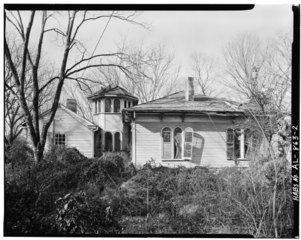
| EAST SIDE, SHOWING OCTAGONAL CROSS-HALL - Hugh C. Leckey House, State Highway 20 and County Road 48, Leighton, Colbert County, AL | ||||
|---|---|---|---|---|
| Title |
EAST SIDE, SHOWING OCTAGONAL CROSS-HALL - Hugh C. Leckey House, State Highway 20 and County Road 48, Leighton, Colbert County, AL |
|||
| Depicted place | Alabama; Colbert County; Leighton | |||
| Date | Documentation compiled after 1933 | |||
| Medium | 4 x 5 in. | |||
| Current location |
Library of Congress Prints and Photographs Division Washington, D.C. 20540 USA http://hdl.loc.gov/loc.pnp/pp.print |
|||
| Accession number |
HABS ALA,17-LEIT,1-2 |
|||
| Credit line |
|
|||
| Notes |
|
|||
| Source | https://www.loc.gov/pictures/item/al0076.photos.001676p | |||
| Permission (Reusing this file) |
|
|||

| Object location | | View this and other nearby images on: OpenStreetMap |
|---|
File history
Click on a date/time to view the file as it appeared at that time.
| Date/Time | Thumbnail | Dimensions | User | Comment | |
|---|---|---|---|---|---|
| current | 13:29, 27 June 2014 |  | 4,688 × 3,741 (16.73 MB) | Fæ (talk | contribs) | GWToolset: Creating mediafile for Fæ. HABS batch upload restart 26 June 2014 (p21:101)x |
You cannot overwrite this file.
File usage on Commons
The following page uses this file: