File:ECDM 20240201 Africa floods.pdf

Size of this JPG preview of this PDF file: 800 × 566 pixels. Other resolutions: 320 × 226 pixels | 640 × 453 pixels | 1,024 × 725 pixels | 1,280 × 906 pixels | 2,479 × 1,754 pixels.
Original file (2,479 × 1,754 pixels, file size: 1.23 MB, MIME type: application/pdf)
Captions
Captions
Add a one-line explanation of what this file represents
Summary edit
| Description |
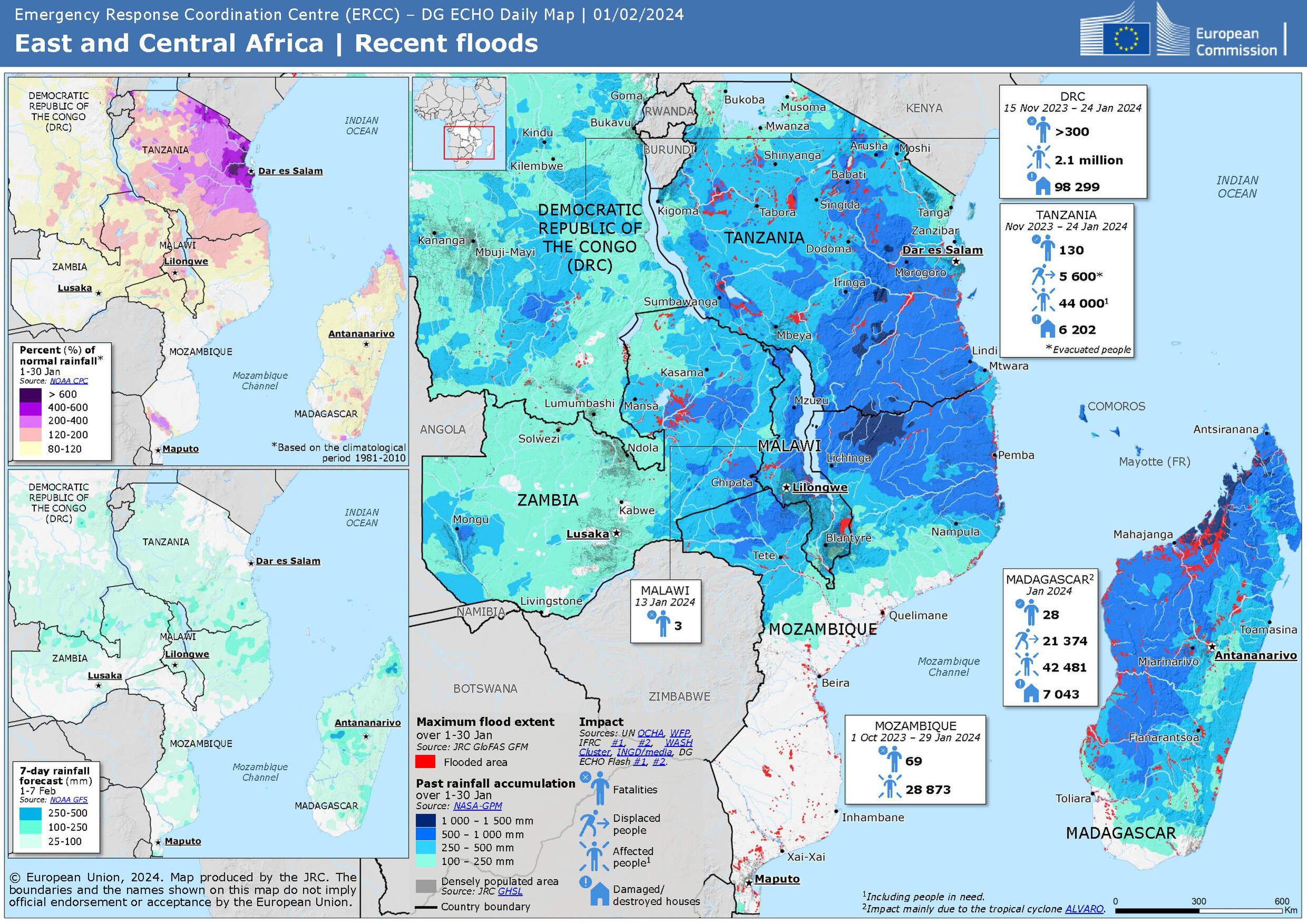
English: East and Central Africa | Recent floods ECHO Daily Map of 01 February 2024 |
| Date | |
| Source | https://erccportal.jrc.ec.europa.eu/ECHO-Products/Maps#/maps/4776 |
| Author | Emergency Response Coordination Centre; Sources: UN OCHA, DG ECHO, WFP, IFRC, WASH Cluster, INGD, media, NASA GPM, NOAA GFS, NOAA CPC, JRC Glofas GFM, JRC GHSL |
Licensing edit
Public documents (any content whatever its medium) produced by the Commission or by entities on its behalf published by the Commission or the Publications Office or which have not been published for economic or other practical reasons, such as studies, reports and other data shall be made available for reuse unless otherwise specified[1] without restrictions according to 2011/833/EU: Commission Decision of 12 December 2011 on the reuse of Commission documents
Note: Content on ec.europa.eu or its data portal is published with the specified restrictions of the CC BY 4.0 license.
| |
File history
Click on a date/time to view the file as it appeared at that time.
| Date/Time | Thumbnail | Dimensions | User | Comment | |
|---|---|---|---|---|---|
| current | 21:57, 2 February 2024 |  | 2,479 × 1,754 (1.23 MB) | Lupe (talk | contribs) | Uploaded a work by Emergency Response Coordination Centre; Sources: UN OCHA, DG ECHO, WFP, IFRC, WASH Cluster, INGD, media, NASA GPM, NOAA GFS, NOAA CPC, JRC Glofas GFM, JRC GHSL from https://erccportal.jrc.ec.europa.eu/ECHO-Products/Maps#/maps/4776 with UploadWizard |
You cannot overwrite this file.
File usage on Commons
The following 2 pages use this file: