File:ETOPS90 Atlantic.png
No higher resolution available.
ETOPS90_Atlantic.png (435 × 437 pixels, file size: 20 KB, MIME type: image/png)
Captions
Captions
Add a one-line explanation of what this file represents

|
This map image could be re-created using vector graphics as an SVG file. This has several advantages; see Commons:Media for cleanup for more information. If an SVG form of this image is available, please upload it and afterwards replace this template with
{{vector version available|new image name}}.
It is recommended to name the SVG file “ETOPS90 Atlantic.svg”—then the template Vector version available (or Vva) does not need the new image name parameter. |
Summary edit
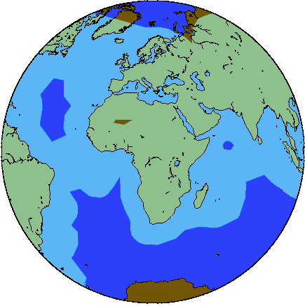
| Description |
Deutsch: Die dunkelblau und dunkelbraun markierten Gebiete sind für ETOPS-120-Flugzeuge verboten.
English: Dark blue or dark brown colours show area forbidden to ETOPS-120 aircrafts.
Français : En foncé les zones océaniques ou continentales interdites aux avions certifié ETOPS-120. |
| Source | |
| Author |
Licensing edit
| I, the copyright holder of this work, release this work into the public domain. This applies worldwide. In some countries this may not be legally possible; if so: I grant anyone the right to use this work for any purpose, without any conditions, unless such conditions are required by law. |
File history
Click on a date/time to view the file as it appeared at that time.
| Date/Time | Thumbnail | Dimensions | User | Comment | |
|---|---|---|---|---|---|
| current | 13:42, 15 April 2006 | | 435 × 437 (20 KB) | Lozère (talk | contribs) | {{fr}}: En foncé les zones océaniques ou continentales interdites aux avions certifié ETOPS-90. {{en}}: Dark blue or dark brown colours show area forbidden to ETOPS-90 aircrafts. |
You cannot overwrite this file.
File usage on Commons
There are no pages that use this file.
File usage on other wikis
The following other wikis use this file:
- Usage on fr.wikipedia.org
- Usage on nl.wikipedia.org
- Usage on uk.wikipedia.org