File:EXTERIOR VIEW WITH RESIDENTIAL COMMUNITY CONTEXT LOOKING EAST ALONG NORTHSIDE OF 3200 BLOCK OF 29TH AVENUE NORTH - Bethel Baptist Church, 3233 Twenty-ninth Avenue, North, HABS ALA,37-BIRM,26-3.tif
Size of this JPG preview of this TIF file: 800 × 584 pixels. Other resolutions: 320 × 234 pixels | 640 × 468 pixels | 1,024 × 748 pixels | 1,280 × 935 pixels | 2,560 × 1,870 pixels | 5,000 × 3,653 pixels.
Original file (5,000 × 3,653 pixels, file size: 17.42 MB, MIME type: image/tiff)
Captions
Captions
Add a one-line explanation of what this file represents
Summary edit
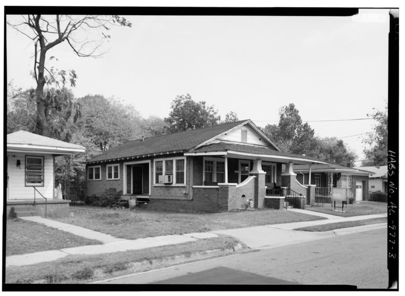
| EXTERIOR VIEW WITH RESIDENTIAL COMMUNITY CONTEXT LOOKING EAST ALONG NORTHSIDE OF 3200 BLOCK OF 29TH AVENUE NORTH - Bethel Baptist Church, 3233 Twenty-ninth Avenue, North, Birmingham, Jefferson County, AL | ||||
|---|---|---|---|---|
| Photographer |
Related names:
|
|||
| Title |
EXTERIOR VIEW WITH RESIDENTIAL COMMUNITY CONTEXT LOOKING EAST ALONG NORTHSIDE OF 3200 BLOCK OF 29TH AVENUE NORTH - Bethel Baptist Church, 3233 Twenty-ninth Avenue, North, Birmingham, Jefferson County, AL |
|||
| Depicted place | Alabama; Jefferson County; Birmingham | |||
| Date | Documentation compiled after 1933 | |||
| Dimensions | 5 x 7 in. | |||
| Current location |
Library of Congress Prints and Photographs Division Washington, D.C. 20540 USA http://hdl.loc.gov/loc.pnp/pp.print |
|||
| Accession number |
HABS ALA,37-BIRM,26-3 |
|||
| Credit line |
|
|||
| Notes |
|
|||
| References |
|
|||
| Source | https://www.loc.gov/pictures/item/al1126.photos.046923p | |||
| Permission (Reusing this file) |
|
|||

| Object location | | View this and other nearby images on: OpenStreetMap |
|---|
File history
Click on a date/time to view the file as it appeared at that time.
| Date/Time | Thumbnail | Dimensions | User | Comment | |
|---|---|---|---|---|---|
| current | 01:22, 1 July 2014 |  | 5,000 × 3,653 (17.42 MB) | Fæ (talk | contribs) | GWToolset: Creating mediafile for Fæ. HABS batch upload 29 June 2014 (101:150) |
You cannot overwrite this file.
File usage on Commons
The following page uses this file: