File:Earthquake PAKISTAN 2011-01-18.png
No higher resolution available.
Earthquake_PAKISTAN_2011-01-18.png (402 × 432 pixels, file size: 118 KB, MIME type: image/png)
Captions
Captions
Add a one-line explanation of what this file represents
Summary edit
| Description |
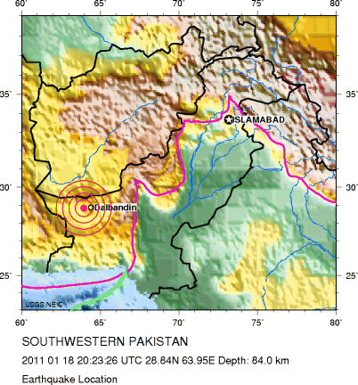
English: major earthquake in the southwestern part of Pakistan (45 km (30 miles) W of Dalbandin), time: 20:23:23 UTC, Location: 28.732°N, 63.928°E, depth: 68 km (42.3 miles), magnitude 7.2 |
| Date | |
| Source | http://neic.usgs.gov/neis/eq_depot/2011/eq_110118_ggbx/neic_ggbx_cy.gif |
| Author | United States Geological Survey |
Licensing edit
This image is in the public domain in the United States because it only contains materials that originally came from the United States Geological Survey, an agency of the United States Department of the Interior. For more information, see the official USGS copyright policy.
|
Original upload log edit
| Date/Time | Dimensions | User | Comment |
|---|---|---|---|
| 20 January 2011, 21:04:04 | 402 × 432 (108178 bytes) | Wolf-Dieter (talk · contribs) | {{Information |Description={{en|1=major earthquake in the southwestern part of Pakistan (45 km (30 miles) W of Dalbandin), time: 20:23:23 UTC, Location: 28.732°N, 63.928°E, depth: 68 km (42.3 miles), magnitude 7.2}} |Source=http://neic.usgs.gov/neis/eq_ |
File history
Click on a date/time to view the file as it appeared at that time.
| Date/Time | Thumbnail | Dimensions | User | Comment | |
|---|---|---|---|---|---|
| current | 16:13, 6 January 2015 | | 402 × 432 (118 KB) | GifTagger (talk | contribs) | Bot: Converting file to superior PNG file. (Source: Earthquake_PAKISTAN_2011-01-18.gif). This GIF was problematic due to transparency and non-greyscale color table. |
You cannot overwrite this file.
File usage on Commons
The following page uses this file:
- File:Earthquake PAKISTAN 2011-01-18.gif (file redirect)
File usage on other wikis
The following other wikis use this file:
- Usage on de.wikipedia.org
- Usage on de.wikinews.org
- Usage on incubator.wikimedia.org