File:East-Hem 001ad.jpg

Original file (3,240 × 1,903 pixels, file size: 709 KB, MIME type: image/jpeg)
Captions
Captions

|
This historical map image could be re-created using vector graphics as an SVG file. This has several advantages; see Commons:Media for cleanup for more information. If an SVG form of this image is available, please upload it and afterwards replace this template with
{{vector version available|new image name}}.
It is recommended to name the SVG file “East-Hem 001ad.svg”—then the template Vector version available (or Vva) does not need the new image name parameter. |

Summary edit
|
|
This map image could be re-created using vector graphics as an SVG file. This has several advantages; see Commons:Media for cleanup for more information. If an SVG form of this image is available, please upload it and afterwards replace this template with
{{vector version available|new image name}}.
It is recommended to name the SVG file “East-Hem 001ad.svg”—then the template Vector version available (or Vva) does not need the new image name parameter. |
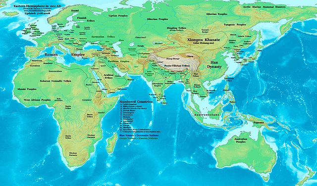
| Description | Eastern Hemisphere in 001 AD. |
| Source | self-made (For reference information, see the Map Source References section below.) |
| Author | Thomas Lessman (Contact!) |
| Permission (Reusing this file) |
I, the copyright holder of this work, hereby publish it under the following license: This file is licensed under the Creative Commons Attribution-Share Alike 3.0 Unported license.
|
| Other versions | see East-Hem_001ad.jpg file history on Wikipedia. |
Map Summary edit
Original Source URL: http://www.thomaslessman.com/History/images/East-Hem_001ad.jpg.
This map of the Eastern Hemisphere in 001 AD was created by Thomas Lessman, based on information from the sources listed below. This map is free for educational use (see Permission info above). When using this map, please mention that it is available for free at www.WorldHistoryMaps.info.
Map Source References edit
- Remember, sources often conflict with each other. This map is only as accurate as the information that is available to me. To report any errors or to help further this work, please click here, or email Thomas Lessman at talessman@yis.us
References for information contained in this map:
1. Borders of Europe are mostly derived from the www.Euratlas.com map of Europe in 001 AD archive copy at the Wayback Machine.
2. Borders of Asian countries are derived primarily from these sources:
- a - The DK Atlas of World History, 2000 Edition; map of The World in 1 CE, (Pages 42-43) was used for information on several Asian borders in this map.
- b - WorldHistoryMaps.com map of the Countries of the World 1/1/36 bce archive copy at the Wayback Machine provides some borders for India and other parts of Asia.
- c - Parthia's border with the Indo-Scythians and Tocharians is derived from Wikipedia articles about Kushan King Heraios, the Indo-Scythians, and the Kushan Empire.
- d - Kashmir/Chach is described in the Wikipedia article about Zeionises.
3. Some information also derives from Wikimedia's map of the World_1_CE, created by User:Javierfv1212.
4. Korean borders derive from this map of Korea_001.png made by Wikipedia User:Historiographer.
5. Much of the information in this map was cross-checked with Bruce Gordon's Regnal Chronologies.
Other Maps by Thomas Lessman edit
| Maps of the eastern hemisphere showing history
Bold dates are available on Wikimedia or Wikipedia. | ||
| Primeval | ||
| Ancient
|
·| 600 BC | 550 BC | 527 BC | 500 BC |
400 BC | ·| 1 AD | 50 AD | 100 AD | 200 AD | 300 AD | | |
| Medieval |
·| 500 AD | 565 AD | 600 AD | 700 AD | | |
| Modern |
·| 1500 AD | · * For historical maps of the whole world, | |
Licensing edit
- You are free:
- to share – to copy, distribute and transmit the work
- to remix – to adapt the work
- Under the following conditions:
- attribution – You must give appropriate credit, provide a link to the license, and indicate if changes were made. You may do so in any reasonable manner, but not in any way that suggests the licensor endorses you or your use.
- share alike – If you remix, transform, or build upon the material, you must distribute your contributions under the same or compatible license as the original.
File history
Click on a date/time to view the file as it appeared at that time.
| Date/Time | Thumbnail | Dimensions | User | Comment | |
|---|---|---|---|---|---|
| current | 06:45, 9 May 2008 | | 3,240 × 1,903 (709 KB) | Talessman (talk | contribs) | {{Information |Description='''Eastern Hemisphere in 001 AD'''. |Source=self-made (For reference information, see below) |Author=Thomas Lessman (Contact!) |Date= |Location= |Permission={{self|cc-by-sa-3.0}} |other |
You cannot overwrite this file.
File usage on Commons
The following 3 pages use this file:
File usage on other wikis
The following other wikis use this file:
- Usage on ar.wikipedia.org
- Usage on ast.wikipedia.org
- Usage on av.wikipedia.org
- Usage on ban.wikipedia.org
- Usage on bn.wikipedia.org
- Usage on bs.wikipedia.org
- Usage on bxr.wikipedia.org
- Usage on ckb.wikipedia.org
- Usage on cs.wikipedia.org
- Usage on de.wikipedia.org
- Usage on en.wikipedia.org
- Usage on es.wikipedia.org
- Usage on eu.wikipedia.org
- Usage on fa.wikipedia.org
- Usage on ga.wikipedia.org
- Usage on gl.wikipedia.org
- Usage on gn.wikipedia.org
- Usage on hu.wikipedia.org
- Usage on ja.wikipedia.org
- Usage on ml.wikipedia.org
- Usage on nl.wikipedia.org
- Usage on no.wikipedia.org
- Usage on pnb.wikipedia.org
- Usage on pt.wikipedia.org
- Usage on rue.wikipedia.org
- Usage on ru.wikipedia.org
- Usage on sd.wikipedia.org
- Usage on sh.wikipedia.org
- Usage on simple.wikipedia.org
- Usage on si.wikipedia.org
View more global usage of this file.