File:East Elevation, South and North Ends - Kennecott Copper Corporation, Leaching Plant, On Copper River and Northwestern Railroad, Kennicott, Valdez-Cordova Census Area, AK HAER AK-1-E (sheet 15 of 26).tif

Size of this JPG preview of this TIF file: 800 × 535 pixels. Other resolutions: 320 × 214 pixels | 640 × 428 pixels | 1,024 × 684 pixels | 1,280 × 855 pixels | 2,560 × 1,711 pixels | 14,402 × 9,625 pixels.
Original file (14,402 × 9,625 pixels, file size: 643 KB, MIME type: image/tiff)
Captions
Captions
Add a one-line explanation of what this file represents
Summary edit
| Warning | The original file is very high-resolution. It might not load properly or could cause your browser to freeze when opened at full size. |
|---|
| East Elevation, South and North Ends - Kennecott Copper Corporation, Leaching Plant, On Copper River and Northwestern Railroad, Kennicott, Valdez-Cordova Census Area, AK | ||||
|---|---|---|---|---|
| Photographer |
Houston, Chris Related names:
|
|||
| Title |
East Elevation, South and North Ends - Kennecott Copper Corporation, Leaching Plant, On Copper River and Northwestern Railroad, Kennicott, Valdez-Cordova Census Area, AK |
|||
| Depicted place | Alaska; Valdez-Cordova Census Area; Kennicott | |||
| Date | Documentation compiled after 1968 | |||
| Current location |
Library of Congress Prints and Photographs Division Washington, D.C. 20540 USA http://hdl.loc.gov/loc.pnp/pp.print |
|||
| Accession number |
HAER AK-1-E (sheet 15 of 26) |
|||
| Credit line |
|
|||
| Notes |
|
|||
| References |
|
|||
| Source | https://www.loc.gov/pictures/item/ak0477.sheet.00015a | |||
| Permission (Reusing this file) |
|
|||
| Other versions |
.png) .png) .png) .png) .png) .png) .png) .png) .png) .png) .png) |
|||

| Object location | | View this and other nearby images on: OpenStreetMap |
|---|
File history
Click on a date/time to view the file as it appeared at that time.
| Date/Time | Thumbnail | Dimensions | User | Comment | |
|---|---|---|---|---|---|
| current | 14:03, 26 June 2014 | 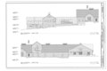 | 14,402 × 9,625 (643 KB) | Fæ (talk | contribs) | GWToolset: Creating mediafile for Fæ. HABS batch upload restart 26 June 2014 (p21:100) TEST of 100 |
You cannot overwrite this file.
File usage on Commons
The following page uses this file: