File:East Elevation, Transverse Section A-A, Longitudinal Section B-B - Bath-Haverhill Bridge, Spanning Ammonoosuc River, bypassed section of Ammanoosuc Street (SR 135), HAER NH-33 (sheet 3 of 4).png

Size of this preview: 800 × 533 pixels. Other resolutions: 320 × 213 pixels | 640 × 427 pixels | 1,024 × 683 pixels | 1,280 × 853 pixels | 2,560 × 1,707 pixels | 14,401 × 9,601 pixels.
Original file (14,401 × 9,601 pixels, file size: 2.53 MB, MIME type: image/png)
Captions
Captions
Add a one-line explanation of what this file represents
| This image is a JPEG version of the original TIF image at File: East Elevation, Transverse Section A-A, Longitudinal Section B-B - Bath-Haverhill Bridge, Spanning Ammonoosuc River, bypassed section of Ammanoosuc Street (SR 135), HAER NH-33 (sheet 3 of 4).tif.
However, any edits to the image should be based on the original TIF version in order to prevent generation loss, and both versions should be updated. Do not make edits based on this version. |
Summary edit
| Warning | The original file is very high-resolution. It might not load properly or could cause your browser to freeze when opened at full size. |
|---|
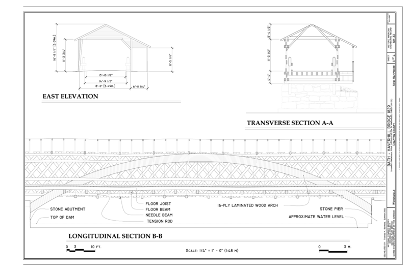
| East Elevation, Transverse Section A-A, Longitudinal Section B-B - Bath-Haverhill Bridge, Spanning Ammonoosuc River, bypassed section of Ammanoosuc Street (SR 135), Woodsville, Grafton County, NH | ||||
|---|---|---|---|---|
| Photographer |
Behrens, Thomas M. Related names:
|
|||
| Title |
East Elevation, Transverse Section A-A, Longitudinal Section B-B - Bath-Haverhill Bridge, Spanning Ammonoosuc River, bypassed section of Ammanoosuc Street (SR 135), Woodsville, Grafton County, NH |
|||
| Depicted place | New Hampshire; Grafton County; Woodsville | |||
| Date | 2004 | |||
| Current location |
Library of Congress Prints and Photographs Division Washington, D.C. 20540 USA http://hdl.loc.gov/loc.pnp/pp.print |
|||
| Accession number |
HAER NH-33 (sheet 3 of 4) |
|||
| Credit line |
|
|||
| Notes |
|
|||
| References |
|
|||
| Source | https://www.loc.gov/pictures/item/nh0272.sheet.00003a | |||
| Permission (Reusing this file) |
|
|||
| Other versions |
,_Woodsville,_Grafton_County,_NH_HAER_NH-33_(sheet_1_of_4).png) ,_Woodsville,_Grafton_County_HAER_NH-33_(sheet_2_of_4).png) |
|||

,_HAER_NH-33_(sheet_3_of_4).png&action=edit§ion=1)
| Object location | | View this and other nearby images on: OpenStreetMap |
|---|
,_HAER_NH-33_(sheet_3_of_4).png¶ms=044.152220_N_-072.037780_E_globe:Earth_class:object_type:object__&language=en)
File history
Click on a date/time to view the file as it appeared at that time.
| Date/Time | Thumbnail | Dimensions | User | Comment | |
|---|---|---|---|---|---|
| current | 20:58, 13 August 2014 | | 14,401 × 9,601 (2.53 MB) | Fæ (talk | contribs) | {{Compressed version|file=File:East_Elevation,_Transverse_Section_A-A,_Longitudinal_Section_B-B_-_Bath-Haverhill_Bridge,_Spanning_Ammonoosuc_River,_bypassed_section_of_Ammanoosuc_Street_(SR_135),_HAER_NH-33_(sheet_3_of_4).tif|thumb=nothumb}} =={{int:fi... |
You cannot overwrite this file.
File usage on Commons
The following 7 pages use this file:
- File:Bath-Haverhill Bridge, Title Sheet - Bath-Haverhill Bridge, Spanning Ammonoosuc River, bypassed section of Ammanoosuc Street (SR 135), Woodsville, Grafton County, NH HAER NH-33 (sheet 1 of 4).png
- File:Bath-Haverhill Bridge, Title Sheet - Bath-Haverhill Bridge, Spanning Ammonoosuc River, bypassed section of Ammanoosuc Street (SR 135), Woodsville, Grafton County, NH HAER NH-33 (sheet 1 of 4).tif
- File:Deck Plan, Longitudinal Section, East Elevation - Bath-Haverhill Bridge, Spanning Ammonoosuc River, bypassed section of Ammanoosuc Street (SR 135), Woodsville, Grafton County HAER NH-33 (sheet 2 of 4).png
- File:Deck Plan, Longitudinal Section, East Elevation - Bath-Haverhill Bridge, Spanning Ammonoosuc River, bypassed section of Ammanoosuc Street (SR 135), Woodsville, Grafton County HAER NH-33 (sheet 2 of 4).tif
- File:East Elevation, Transverse Section A-A, Longitudinal Section B-B - Bath-Haverhill Bridge, Spanning Ammonoosuc River, bypassed section of Ammanoosuc Street (SR 135), HAER NH-33 (sheet 3 of 4).png
- File:East Elevation, Transverse Section A-A, Longitudinal Section B-B - Bath-Haverhill Bridge, Spanning Ammonoosuc River, bypassed section of Ammanoosuc Street (SR 135), HAER NH-33 (sheet 3 of 4).tif
- File:Perspective View - Bath-Haverhill Bridge, Spanning Ammonoosuc River, bypassed section of Ammanoosuc Street (SR 135), Woodsville, Grafton County, NH HAER NH-33 (sheet 4 of 4).tif
,_HAER_NH-33_(sheet_3_of_4).png)
,_HAER_NH-33_(sheet_3_of_4).png&oldid=664322099)