File:East back and north side. - Archie Morrison Rental House, 182 Frisco Street, Clifton, Greenlee County, AZ HABS ARIZ,6-CLIFT,2-2.tif
Size of this JPG preview of this TIF file: 744 × 600 pixels. Other resolutions: 298 × 240 pixels | 596 × 480 pixels | 953 × 768 pixels | 1,271 × 1,024 pixels | 2,542 × 2,048 pixels | 5,000 × 4,029 pixels.
Original file (5,000 × 4,029 pixels, file size: 19.21 MB, MIME type: image/tiff)
Captions
Captions
Add a one-line explanation of what this file represents
Summary edit
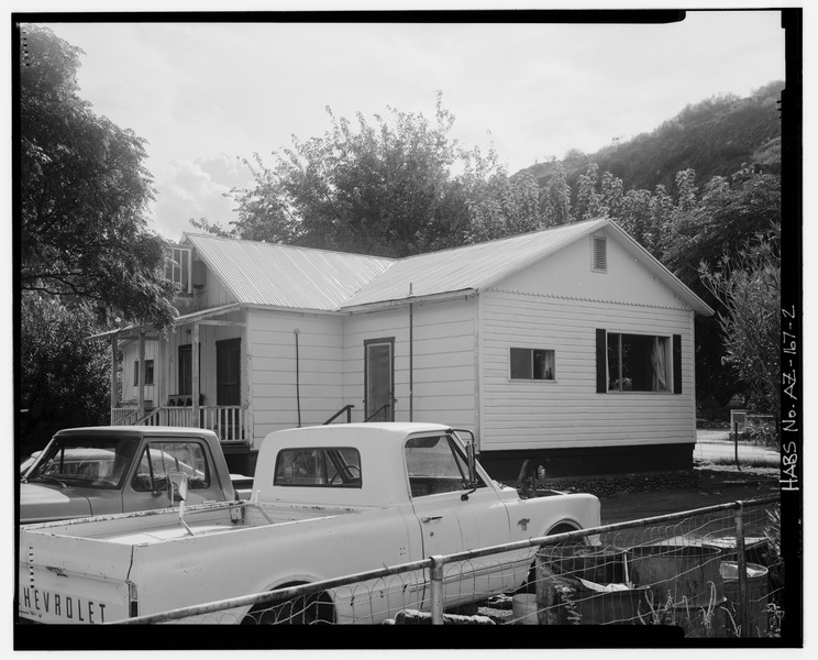
| East back and north side. - Archie Morrison Rental House, 182 Frisco Street, Clifton, Greenlee County, AZ | ||||
|---|---|---|---|---|
| Photographer |
Related names:
|
|||
| Title |
East back and north side. - Archie Morrison Rental House, 182 Frisco Street, Clifton, Greenlee County, AZ |
|||
| Depicted place | Arizona; Greenlee County; Clifton | |||
| Date | Documentation compiled after 1933 | |||
| Dimensions | 4 x 5 in. | |||
| Current location |
Library of Congress Prints and Photographs Division Washington, D.C. 20540 USA http://hdl.loc.gov/loc.pnp/pp.print |
|||
| Accession number |
HABS ARIZ,6-CLIFT,2-2 |
|||
| Credit line |
|
|||
| Notes |
|
|||
| References |
|
|||
| Source | https://www.loc.gov/pictures/item/az0315.photos.180350p | |||
| Permission (Reusing this file) |
|
|||

| Object location | | View this and other nearby images on: OpenStreetMap |
|---|
File history
Click on a date/time to view the file as it appeared at that time.
| Date/Time | Thumbnail | Dimensions | User | Comment | |
|---|---|---|---|---|---|
| current | 13:58, 29 June 2014 |  | 5,000 × 4,029 (19.21 MB) | Fæ (talk | contribs) | GWToolset: Creating mediafile for Fæ. HABS batch upload 26 June 2014 (151:200) |
You cannot overwrite this file.
File usage on Commons
The following page uses this file: