File:East of England Counties.png

Size of this preview: 663 × 599 pixels. Other resolutions: 266 × 240 pixels | 531 × 480 pixels | 850 × 768 pixels | 1,133 × 1,024 pixels | 1,593 × 1,440 pixels.
Original file (1,593 × 1,440 pixels, file size: 1.06 MB, MIME type: image/png)
Captions
Captions
Add a one-line explanation of what this file represents
Summary edit
| Description |
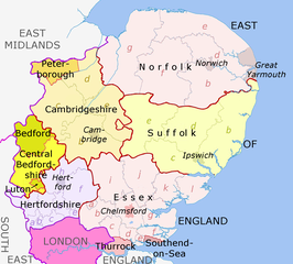
English: Map of the East of England region, showing its counties and administrative districts. The county colours are the same as those in File:English metropolitan and non-metropolitan counties 2009.svg.
Equirectangular map projection on WGS 84 datum, with N/S stretched 160% Geographic limits:
|
| Date | (UTC) |
| Source |
File:East of England counties 2019 map.jpg, This file was derived from:
|
| Author |
|


Licensing edit

|
Permission is granted to copy, distribute and/or modify this document under the terms of the GNU Free Documentation License, Version 1.2 or any later version published by the Free Software Foundation; with no Invariant Sections, no Front-Cover Texts, and no Back-Cover Texts. A copy of the license is included in the section entitled GNU Free Documentation License. |
File history
Click on a date/time to view the file as it appeared at that time.
| Date/Time | Thumbnail | Dimensions | User | Comment | |
|---|---|---|---|---|---|
| current | 15:33, 31 March 2022 | | 1,593 × 1,440 (1.06 MB) | Ulamm (talk | contribs) | neighbouring regions with pale labels |
| 11:37, 31 March 2022 |  | 1,593 × 1,440 (1.07 MB) | Ulamm (talk | contribs) | improvements of colour code | |
| 10:34, 24 March 2022 |  | 1,593 × 1,440 (1.07 MB) | Ulamm (talk | contribs) | Labelling of surroundings | |
| 09:58, 24 March 2022 |  | 1,593 × 1,440 (1.1 MB) | Ulamm (talk | contribs) | {{Information |Description={{en|Map of the East of England region, showing its counties and administrative districts. The county colours are the same as those in File:English metropolitan and non-metropolitan counties 2009.svg. Equirectangular map projection on WGS 84 datum, with N/S stretched 160% Geographic limits: *West: 0.8W *East: E *North: N *South: 51.4N }} |Source=File:East of England counties 2019 map.jpg, {{Derived from|East_of_England_districts_2... |
You cannot overwrite this file.
File usage on Commons
There are no pages that use this file.
File usage on other wikis
The following other wikis use this file:
- Usage on de.wikipedia.org