File:Eastern Front Kharkov Vicinity 1941-06 to 1941-12.png
No higher resolution available.
Eastern_Front_Kharkov_Vicinity_1941-06_to_1941-12.png (300 × 248 pixels, file size: 35 KB, MIME type: image/png)
Captions
Captions
Add a one-line explanation of what this file represents

|
Permission is granted to copy, distribute and/or modify this document under the terms of the GNU Free Documentation License, Version 1.2 or any later version published by the Free Software Foundation; with no Invariant Sections, no Front-Cover Texts, and no Back-Cover Texts. A copy of the license is included in the section entitled GNU Free Documentation License. |
| This file is licensed under the Creative Commons Attribution-Share Alike 3.0 Unported license. | ||
| ||
| This licensing tag was added to this file as part of the GFDL licensing update. |
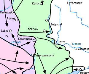
English: Eastern front of the Second World War in the vicinity of Kharkov and Belgorod. A possibly useful 300-pixel-wide map for the first battle of Kharkov.
- Pink area is captured by Germans up to September 1st 1941
- Purple area is captured by Germans up to September 9th 1941
- Green area is captured by Germans up to December 5th 1941
Русский: Карта боевых действий на Восточной Украине, осень 1941 года. Цветом обозначены захваченные Германией территории:
- Розовый — к 1 сентября;
- Фиолетовый — к 9 сентября;
- Зелёный — к 5 декабря.
Cropped from Image:Eastern Front 1941-06 to 1941-12.png [1].
![[1]](https://upload.wikimedia.org/wikipedia/commons/b/b8/Eastern_Front_1941-06_to_1941-12.png)
derivative works edit
Derivative works of this file: Fronte Meridionale dal 1941-06 al 1941-12.png
File history
Click on a date/time to view the file as it appeared at that time.
| Date/Time | Thumbnail | Dimensions | User | Comment | |
|---|---|---|---|---|---|
| current | 22:24, 2 February 2006 | | 300 × 248 (35 KB) | Hautala (talk | contribs) | {{GFDL}} Eastern front of the Second World War in the vicinity of Kharkov and Belgorod. A possibly useful 300-pixel-wide map for the first battle of Kharkov. :Pink area is captured by Germans up to September 1st 1941 :Purple area is captured by Germans u |
You cannot overwrite this file.
File usage on Commons
The following 2 pages use this file:
File usage on other wikis
The following other wikis use this file:
- Usage on et.wikipedia.org
- Usage on fi.wikipedia.org
- Usage on fr.wikipedia.org
- Usage on he.wikipedia.org
- Usage on it.wikipedia.org
- Usage on vi.wikipedia.org