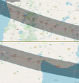
File:Eclipse Solar Total del 14 de Diciembre de 2020 - Totalidad en Chile y Argentina.png

Original file (2,207 × 2,301 pixels, file size: 1 MB, MIME type: image/png)
Captions
Captions
Summary edit
| DescriptionEclipse Solar Total del 14 de Diciembre de 2020 - Totalidad en Chile y Argentina.png |
Español: Eclipse del 14.12.2020. Chile y Argentina: provincias de Neuquén, Río Negro y Buenos Aires.
Ver: Eclipse Solar Total del 14.12.2020 en toda la Argentina. |
| Date | |
| Source | Own work based on www.openstreetmap.org - Mapa "Estándar", Fred Espenak y "M1 Sistema Astronómico"© |
| Author | Fernando de Gorocica |
Licensing edit
- You are free:
- to share – to copy, distribute and transmit the work
- to remix – to adapt the work
- Under the following conditions:
- attribution – You must give appropriate credit, provide a link to the license, and indicate if changes were made. You may do so in any reasonable manner, but not in any way that suggests the licensor endorses you or your use.
- share alike – If you remix, transform, or build upon the material, you must distribute your contributions under the same or compatible license as the original.

|
This work contains information from OpenStreetMap, which is made available under the Open Database License (ODbL).
The ODbL does not require any particular license for maps produced from ODbL data. Prior to 1 August 2020, map tiles produced by the OpenStreetMap Foundation were licensed under the CC-BY-SA-2.0 license. Maps produced by other people may be subject to other licences.Open Database LicenseODbLhttp://opendatacommons.org/licenses/odbl/1.0/true |
File history
Click on a date/time to view the file as it appeared at that time.
| Date/Time | Thumbnail | Dimensions | User | Comment | |
|---|---|---|---|---|---|
| current | 19:54, 15 July 2018 |  | 2,207 × 2,301 (1 MB) | Fernando de Gorocica (talk | contribs) | Desde Sierra Colorada, por la RP 67, hasta el 18.9 kms. Luego desvío hacia la derecha y por camino consolidado caminar 19 kms. y de ahí 3,97 kms. en dirección Norte. Allí Ocurrirá el Eclipse Máximo. |
| 20:10, 14 July 2018 |  | 2,207 × 2,301 (1 MB) | Fernando de Gorocica (talk | contribs) | Eclipse Máximo en la ruta del cono de sombra (totalidad)ː Latitudː 40° 20' 7,44" Sur y Longitudː 67° 57' 28,44 Oeste. | |
| 00:19, 13 July 2018 |  | 2,207 × 2,301 (1 MB) | Fernando de Gorocica (talk | contribs) | Desde Sierra Colorada (RN N° 23) y por la Ruta Provincial N° 67, hacer 23 kms. y desde allí otros 23 kms. en dirección Norte, en ese punto ocurrirá el Eclipse Máximo. | |
| 16:50, 12 July 2018 |  | 2,207 × 2,301 (1 MB) | Fernando de Gorocica (talk | contribs) | User created page with UploadWizard |
You cannot overwrite this file.
File usage on Commons
The following page uses this file:
File usage on other wikis
The following other wikis use this file:
- Usage on es.wikipedia.org
Metadata
This file contains additional information such as Exif metadata which may have been added by the digital camera, scanner, or software program used to create or digitize it. If the file has been modified from its original state, some details such as the timestamp may not fully reflect those of the original file. The timestamp is only as accurate as the clock in the camera, and it may be completely wrong.
| Horizontal resolution | 37.79 dpc |
|---|---|
| Vertical resolution | 37.79 dpc |