File:Eclipse Solar Total del 2 de Julio de 2019 - Totalidad.png

Original file (1,421 × 2,190 pixels, file size: 1.08 MB, MIME type: image/png)
Captions
Captions
Summary edit
| Description |
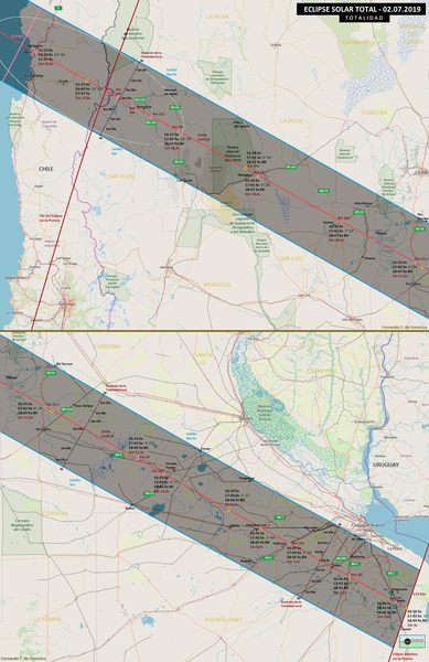
Español: El mapa muestra la ruta de la totalidad en todo el territorio argentino y chileno, es decir cuando el Sol está cubierto o eclipsado un 100%, pasando por las provincias argentinas de San Juan, La Rioja, San Luis, Córdoba, Santa Fe y Buenos Aires.
En la línea central -en rojo- hay puntos amarillos y rosados que describen, para el lugar dado, la hora del comienzo del eclipse, la del eclipse medio y la altura del Sol (en verde) y la hora del último contacto de la Luna con el Sol. Debajo en bordó, la duración del oscurecimiento máximo local en minutos y segundos. La altura es aparente, es decir con refracción atmosférica. En donde dice "BH" el evento ocurre cuando el Sol ya está debajo del horizonte. En cada punto rosa, que se encuentran en una ruta, se describe los kilómetros desde la ciudad más cercana o desde Buenos Aires según el caso. Las tres líneas negras perpendiculares a la línea central, al principio, mitad y al final de la ruta del cono de sombra terrestre representan, en cada punto, los minutos y segundos de duración del eclipse u oscurecimiento máximo local, que disminuye en tiempo hasta cero hacia los límites norte y sur. |
| Date | |
| Source | Own work based on www.openstreetmap.org - Mapa "Estándar", datos del "M1 Sistema Astronómico"© y gráfica según Fred Espenak. |
| Author | Fernando de Gorocica |
Licensing edit
- You are free:
- to share – to copy, distribute and transmit the work
- to remix – to adapt the work
- Under the following conditions:
- attribution – You must give appropriate credit, provide a link to the license, and indicate if changes were made. You may do so in any reasonable manner, but not in any way that suggests the licensor endorses you or your use.
- share alike – If you remix, transform, or build upon the material, you must distribute your contributions under the same or compatible license as the original.
| This work contains information from OpenStreetMap, which is made available under the Open Database License (ODbL).
The ODbL does not require any particular license for maps produced from ODbL data. Prior to 1 August 2020, map tiles produced by the OpenStreetMap Foundation were licensed under the CC-BY-SA-2.0 license. Maps produced by other people may be subject to other licences. |
File history
Click on a date/time to view the file as it appeared at that time.
| Date/Time | Thumbnail | Dimensions | User | Comment | |
|---|---|---|---|---|---|
| current | 19:00, 10 March 2019 | | 1,421 × 2,190 (1.08 MB) | Fernando de Gorocica (talk | contribs) | Agregué más localidades y puntos sobre la línea central en algunas rutas sanjuaninas. |
| 11:26, 5 March 2019 |  | 1,421 × 2,190 (1.08 MB) | Fernando de Gorocica (talk | contribs) | User created page with UploadWizard |
You cannot overwrite this file.
File usage on Commons
The following 2 pages use this file:
File usage on other wikis
The following other wikis use this file:
- Usage on es.wikipedia.org