File:Elayet of temesvar-sr.png
Size of this preview: 464 × 599 pixels. Other resolutions: 186 × 240 pixels | 372 × 480 pixels | 833 × 1,075 pixels.
Original file (833 × 1,075 pixels, file size: 109 KB, MIME type: image/png)
Captions
Captions
Add a one-line explanation of what this file represents
Summary edit
| Description |
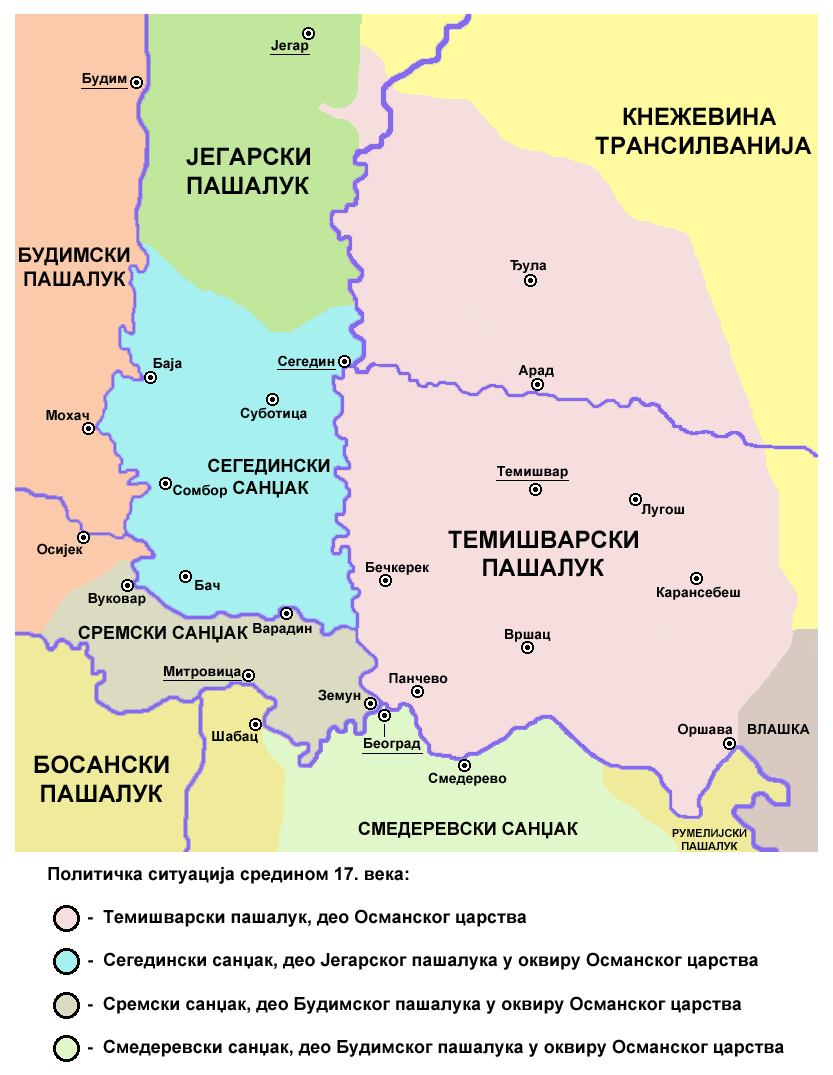
English: Historic map of the Eyalet of Temeşvar, Sanjak of Sirem and Sanjak of Segedin. Српски / srpski: Историјска мапа Темишварског пашалука, Сремског санџака и Сегединског санџака. |
| Date | |
| Source | Own work |
| Author | PANONIAN |
Licensing edit
I, the copyright holder of this work, hereby publish it under the following license:
| This file is made available under the Creative Commons CC0 1.0 Universal Public Domain Dedication. | |
| The person who associated a work with this deed has dedicated the work to the public domain by waiving all of their rights to the work worldwide under copyright law, including all related and neighboring rights, to the extent allowed by law. You can copy, modify, distribute and perform the work, even for commercial purposes, all without asking permission.
|
References edit
- Petrit Imami, Srbi i Albanci kroz vekove, Beograd, 2000.
- The Times History of Europe, Times Books, 2002.
- Istorijski atlas, Zavod za udžbenike i nastavna sredstva - Zavod za kartografiju "Geokarta", Beograd, 1999.
- Milan Tutorov, Banatska rapsodija - istorika Zrenjanina i Banata, Novi Sad, 2001.
- Peter Rokai - Zoltan Đere - Tibor Pal - Aleksandar Kasaš, Istorija Mađara, Beograd, 2002.
- Dr Dušan J. Popović, Srbi u Vojvodini, knjiga 1, Novi Sad, 1990.
- Sima M. Ćirković, Srbi među evropskim narodima, Beograd, 2004.
- Milutin Perović - Relja Novaković, Istorija za III razred gimnazije (opšti tip i društveno-jezički smer) i stručnih škola, Beograd, 1997.
- Milutin Perović - Milo Strugar, Istorija za 7. razred osnovne škole, Beograd - Novi Sad, 1993.
- Sima Ćirković, Istorija za II razred gimnazije prirodno-matematičkog smera, Beograd, 1997.
File history
Click on a date/time to view the file as it appeared at that time.
| Date/Time | Thumbnail | Dimensions | User | Comment | |
|---|---|---|---|---|---|
| current | 11:44, 20 October 2013 | | 833 × 1,075 (109 KB) | PANONIAN (talk | contribs) | {{Information |Description ={{en|1=Historic map of the Eyalet of Temeşvar, Sanjak of Sirem and Sanjak of Segedin.}} |Source ={{own}} |Author =PANONIAN |Date =2013 |Permission = |other_versions = }} |
You cannot overwrite this file.
File usage on Commons
There are no pages that use this file.
File usage on other wikis
The following other wikis use this file:
- Usage on mk.wikipedia.org
- Usage on sr.wikipedia.org