File:Elephant Island map-en.svg

Size of this PNG preview of this SVG file: 702 × 433 pixels. Other resolutions: 320 × 197 pixels | 640 × 395 pixels | 1,024 × 632 pixels | 1,280 × 790 pixels | 2,560 × 1,579 pixels.
Original file (SVG file, nominally 702 × 433 pixels, file size: 68 KB)
Captions
Captions
Add a one-line explanation of what this file represents
| Description |
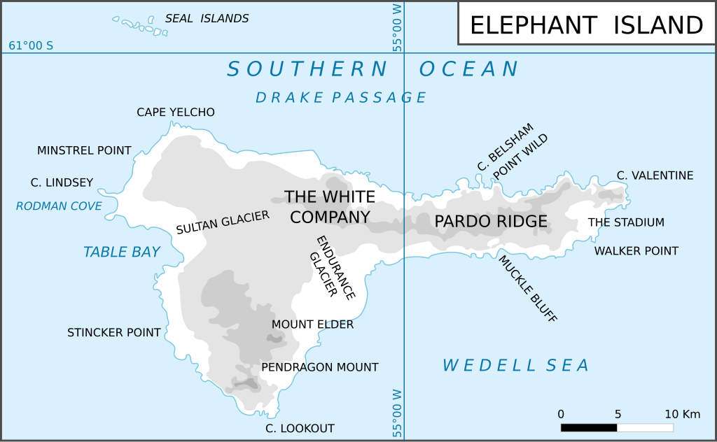
Map of Elephant Island, relief Français : Carte des reliefs de l'île de l'Éléphant English: Map of Elephant Island, relief |
| Date | (UTC) |
| Source | |
| Author |
|
| Other versions |
Derivative works of this file: |
.svg)
| This is a retouched picture, which means that it has been digitally altered from its original version. Modifications: Version anglaise. The original can be viewed here: Ile de l'Éléphant (carte-fr).svg:
|
This file is licensed under the Creative Commons Attribution-Share Alike 3.0 Unported license.
- You are free:
- to share – to copy, distribute and transmit the work
- to remix – to adapt the work
- Under the following conditions:
- attribution – You must give appropriate credit, provide a link to the license, and indicate if changes were made. You may do so in any reasonable manner, but not in any way that suggests the licensor endorses you or your use.
- share alike – If you remix, transform, or build upon the material, you must distribute your contributions under the same or compatible license as the original.
Original upload log edit
This image is a derivative work of the following images:
- File:Elephant_map.png licensed with Cc-by-sa-3.0-migrated, GFDL
- 2006-05-08T05:16:05Z Gi 702x433 (135852 Bytes) {{Information |Description=Map of Elephant Island, relief |Source=several |Date=08-05-2006 |Author=Giovanni Fattori |Permission=Free license |other_versions= }}
- File:Ile_de_l'Éléphant_(carte-fr).svg licensed with Cc-by-sa-3.0-migrated, GFDL
- 2010-04-19T10:53:54Z Trex 702x433 (69290 Bytes) {{Information |Description={{fr|1=Carte des reliefs de l'île de l'Éléphant}} {{en|1=Map of Elephant Island, relief}} |Source=*[[:File:Elephant_map.png|]] |Date=2010-04-19 10:52 (UTC) |Author=*[[:File:Elephant_map.png|]]: Giova
Uploaded with derivativeFX
File history
Click on a date/time to view the file as it appeared at that time.
| Date/Time | Thumbnail | Dimensions | User | Comment | |
|---|---|---|---|---|---|
| current | 16:36, 5 March 2012 | | 702 × 433 (68 KB) | MyNameIsNeo (talk | contribs) | Fixed the alignment of the background. Fixed the name of Sultan Glacier. I consider these changes to be minor. Changes were made in Inkscape. |
| 11:22, 14 June 2010 |  | 702 × 433 (68 KB) | Treehill (talk | contribs) | {{Information |Description=Map of Elephant Island, relief {{fr|Carte des reliefs de l'île de l'Éléphant}} {{en|Map of Elephant Island, relief}} |Source=*File:Elephant_map.png *File:Ile_de_l'Éléphant_(carte-fr).svg |Date=2010-06-14 11:04 ( |
You cannot overwrite this file.
File usage on Commons
The following page uses this file:
- File:Elephant Island (map-en).svg (file redirect)
.svg&redirect=no)
File usage on other wikis
The following other wikis use this file:
- Usage on az.wikipedia.org
- Usage on ceb.wikipedia.org
- Usage on cs.wikipedia.org
- Usage on de.wikipedia.org
- Usage on en.wikipedia.org
- Elephant Island
- Cape Yelcho
- Pardo Ridge
- Endurance Point
- Borceguí Island
- Walker Point
- Cape Valentine
- Sintika Cove
- Gurkovska Cove
- The Stadium (cirque)
- Slavyanka Beach
- Trifonov Point
- Piperkov Point
- Zlatni Pyasatsi Cove
- Krastanov Cove
- Boyadzhiev Point
- Mendoza Cove
- Kapka Lake
- Ronalds Point
- Saffar Island
- Biruni Island
- Eratosthenes Point
- Digges Cove
- Snellius Glacier
- Usage on hu.wikipedia.org
- Usage on ka.wikipedia.org
- Usage on ko.wikipedia.org
- Usage on lld.wikipedia.org
- Usage on mk.wikipedia.org
- Usage on nl.wikipedia.org
- Usage on nn.wikipedia.org
View more global usage of this file.