File:Elevations - Kingsley Plantation, Slave Quarters, 11676 Palmetto Avenue, Jacksonville, Duval County, FL HABS FL-478-A (sheet 2 of 2).png

Original file (14,401 × 9,601 pixels, file size: 2.77 MB, MIME type: image/png)
Captions
Captions
| This image is a JPEG version of the original TIF image at File: Elevations - Kingsley Plantation, Slave Quarters, 11676 Palmetto Avenue, Jacksonville, Duval County, FL HABS FL-478-A (sheet 2 of 2).tif.
However, any edits to the image should be based on the original TIF version in order to prevent generation loss, and both versions should be updated. Do not make edits based on this version. |
Summary edit
| Warning | The original file is very high-resolution. It might not load properly or could cause your browser to freeze when opened at full size. |
|---|
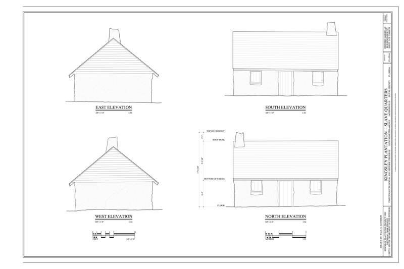
| Elevations - Kingsley Plantation, Slave Quarters, 11676 Palmetto Avenue, Jacksonville, Duval County, FL | ||||
|---|---|---|---|---|
| Photographer |
Davidson, Paul A., creator |
|||
| Title |
Elevations - Kingsley Plantation, Slave Quarters, 11676 Palmetto Avenue, Jacksonville, Duval County, FL |
|||
| Depicted place | Florida; Duval County; Jacksonville | |||
| Date | 2005 | |||
| Current location |
Library of Congress Prints and Photographs Division Washington, D.C. 20540 USA http://hdl.loc.gov/loc.pnp/pp.print |
|||
| Accession number |
HABS FL-478-A (sheet 2 of 2) |
|||
| Credit line |
|
|||
| Notes |
The Quarters are perhaps most notable for their siting and spatial organization. The 32 houses were arrayed in a vast semicircular arc (approximate 350 radius) which was bisected by Palmetto Avenue, the entrance road to the plantation. The two houses adjacent to the road (E1 and W1) and the two houses at the ends (E16 and W16) were built larger than the others. In plan each of the quarters consisted of one or two rooms with a fireplace at one end. The walls of the quarters were constructed of tabby poured into molds that extended the full height of the building, and then plastered. Wood framing supported the shingled roof. Remnants of tabby floors survive in several of the quarters. At an unknown date, the fireplaces in several of the quarters were rebuilt in clay brick.
|
|||
| References |
Related names:
|
|||
| Source | https://www.loc.gov/pictures/item/fl0540.sheet.00002a | |||
| Permission (Reusing this file) |
|
|||
| Other versions |
.png) |
|||

.png&action=edit§ion=1)
| Object location | | View this and other nearby images on: OpenStreetMap |
|---|
.png¶ms=030.331940_N_-081.655829_E_globe:Earth_class:object_type:object__&language=en)
File history
Click on a date/time to view the file as it appeared at that time.
| Date/Time | Thumbnail | Dimensions | User | Comment | |
|---|---|---|---|---|---|
| current | 21:45, 19 July 2014 | | 14,401 × 9,601 (2.77 MB) | Fæ (talk | contribs) | {{Compressed version|file=File:Elevations_-_Kingsley_Plantation,_Slave_Quarters,_11676_Palmetto_Avenue,_Jacksonville,_Duval_County,_FL_HABS_FL-478-A_(sheet_2_of_2).tif|thumb=nothumb}} =={{int:filedesc}}== {{Photograph | accession number = HABS FL-478... |
You cannot overwrite this file.
File usage on Commons
The following 4 pages use this file:
- File:Elevations - Kingsley Plantation, Slave Quarters, 11676 Palmetto Avenue, Jacksonville, Duval County, FL HABS FL-478-A (sheet 2 of 2).png
- File:Elevations - Kingsley Plantation, Slave Quarters, 11676 Palmetto Avenue, Jacksonville, Duval County, FL HABS FL-478-A (sheet 2 of 2).tif
- File:Title page, plan - Kingsley Plantation, Slave Quarters, 11676 Palmetto Avenue, Jacksonville, Duval County, FL HABS FL-478-A (sheet 1 of 2).png
- File:Title page, plan - Kingsley Plantation, Slave Quarters, 11676 Palmetto Avenue, Jacksonville, Duval County, FL HABS FL-478-A (sheet 1 of 2).tif
.png)
.png&oldid=664322148)