File:Ely Mound west of Rose Hill.jpg

Size of this preview: 800 × 450 pixels. Other resolutions: 320 × 180 pixels | 640 × 360 pixels | 1,024 × 576 pixels | 1,280 × 720 pixels | 2,816 × 1,584 pixels.
Original file (2,816 × 1,584 pixels, file size: 1.16 MB, MIME type: image/jpeg)
Captions
Captions
Add a one-line explanation of what this file represents
|
This is an image of a place or building that is listed on the National Register of Historic Places in the United States of America. Its reference number is 83003287. |
| Camera location | | View this and other nearby images on: OpenStreetMap |
|---|
| Description |
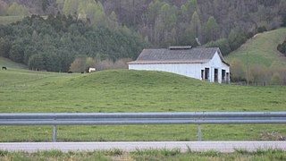
English: Southern side of the Ely Mound, located along the northern side of U.S. Route 58 west of Rose Hill in Lee County, Virginia, United States. As a significant archaeological site, it is listed on the National Register of Historic Places. |
||
| Date | Taken on 20 April 2014 | ||
| Source | Own work | ||
| Author | Nyttend | ||
| Permission (Reusing this file) |
|
||
| Other versions | None |
File history
Click on a date/time to view the file as it appeared at that time.
| Date/Time | Thumbnail | Dimensions | User | Comment | |
|---|---|---|---|---|---|
| current | 01:22, 29 April 2014 | | 2,816 × 1,584 (1.16 MB) | Nyttend (talk | contribs) | {{NRHP|83003287}} {{Location|36|39|22|N|83|24|8|W}} {{Information |Description={{en|Southern side of the {{w|Ely Mound}}, located along the northern side of {{w|U.S. Route 58}} west of {{w|Rose Hill, Lee County, Virginia|Rose Hill}} in {{w|Lee County,... |
You cannot overwrite this file.
File usage on Commons
There are no pages that use this file.
File usage on other wikis
The following other wikis use this file:
- Usage on en.wikipedia.org
- Usage on www.wikidata.org